EVA Report – February 21th

Crew 275 EVA Report 21-02-2023

EVA # 7

Author: Alexandre VINAS (crew astronomer and EVA leader)

Purpose of EVA: Installation of the LOAC instrument & Maintenance of the other atmospheric instruments

Start time: 9:00

End time: 10:41

Narrative:

9:01 EVA crew entered the airlock

9:27 Installation of the LOAC. To be launched, the LOAC just requires to be connected to a battery and to be turned on. This was successfully done.

10:16 Removal of a part of the MegaAres antenna for maintenance. The spheric part of the antenna had to be removed very carefully to not damage the rest of the mast. It was a success as well.

10:29 Removal of the upper mast of the weather station. A piece of tape had to be removed to take the upper mast away carefully. All the purposes of the EVA have been accomplished.

10:34 EVA crew back in the MDRS with the material to be fixed.

10:41 End of the depressurization. EVA crew back to the Hab.

Destination: Between the Hab and Marble Ritual near the road.

Coordinates (use UTM WGS 84): N4251000 E518500

Participants: EVA leader : Alexandre Vinas (Crew Astronomer), Marie Delaroche (Crew Journalist), Corentin Senaux (HSO)

Road(s) and routes per MDRS Map: See attached file

Mode of travel: Walking

EVA Report – February 20th

Crew 275 EVA Report 20Feb2023

EVA # 6

Author: Alice Chapiron, EVA Leader and Crew Scientist

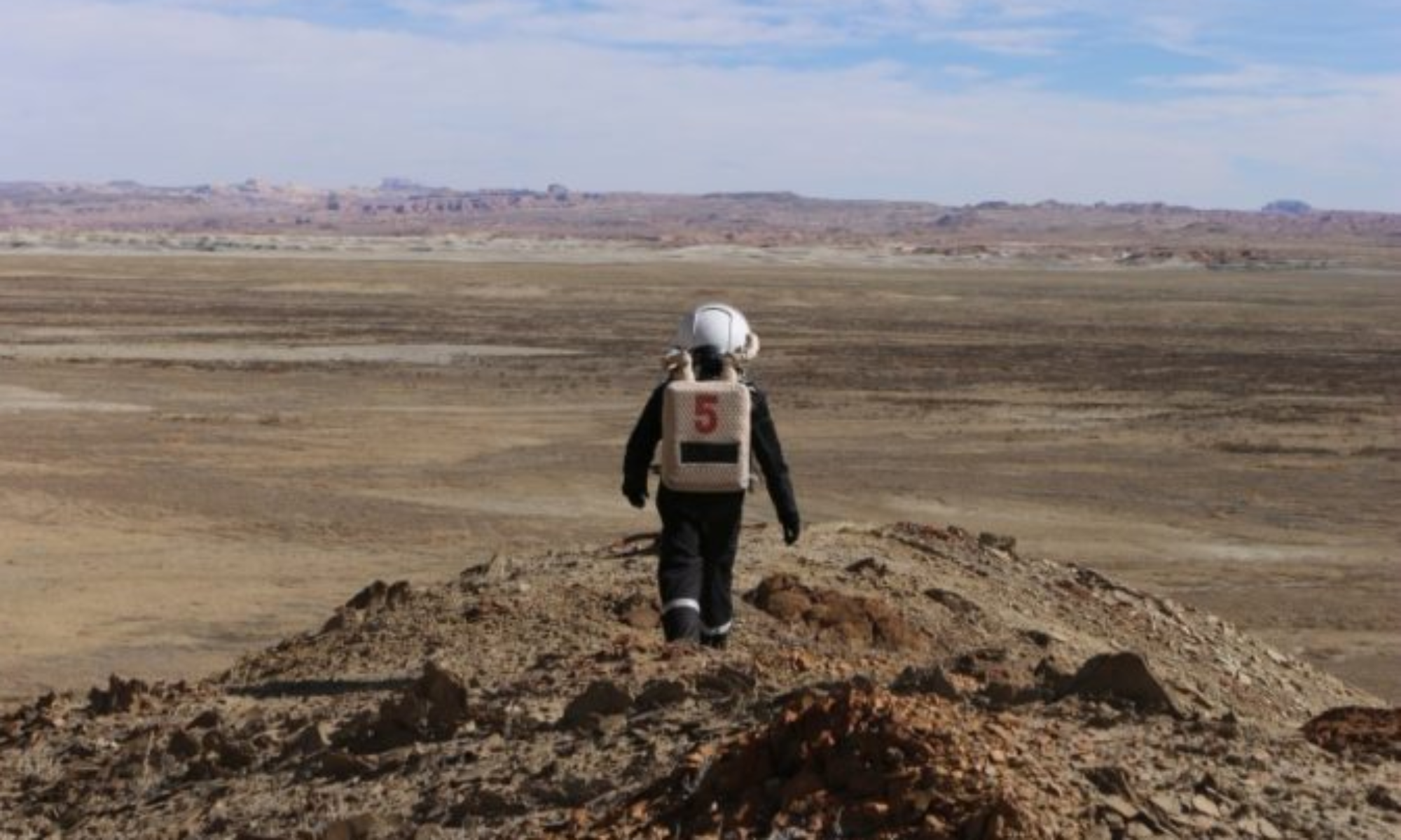
Purpose of EVA: The purpose of the EVA was to do photogrammetry of North Ridge with drones.

Start time: 9:02

End time: 11:50

Narrative:

09:02: Airlock closed.

09:09: Rovers Curiosity and Spirit unplugged. We then depart from the hab at 09:12.

09:14: Rovers parked at the right location near the Mega-Ares, METEO and Purple Air instruments.

09:30: Weather Station and Purple Air data copied. Batteries changed. New recording started. Mega-Ares data copied.

09:36: Beginning of the Mega-Ares test. We didn’t have time to finish all the test, so we preferred to continue with the EVA as it was not the main purpose of today.

09:50: Departure from the Mega-Ares, METEO and Purple Air instrument.

09:58: We had to stop to conduct radio tests because the EVA Leader had her antenna inside her helmet.

10:06: Parked at the right location, near the beginning of the gateway to Candor. Walking towards the desired location.

10:10: Arrival on site for the photogrammetry experiments.

10:23: Launching the drone and starting to place the markers coupled with the sample collection.

10:37: The hat of the Crew Scientist fell off, which slightly impaired her vision. The crew botanist secured her way to a safe place and then the problem was solved by removing the hat from the helmet. It was solved in 5 minutes.

11:01: The crew Scientist microphone got off her head. She could not hear clearly the others, neither talk to them. The Crew Botanist took the head of communication. They gathered with the Crew engineer who was nearby.

11:10: The crew Scientist put back the microphone to solve the problem, so the communication could continue safely. We went back to our activities.

11:20: Loss of contact. Both the EVA Leader and the Crew Botanist couldn’t speak nor be heard. The problem was certainly coming from the fact we were all on channel 1 following the previous problem. This was solved after running some tests and being advised by both HabCom and Mission Support. Departure from North Ridge towards the rover.

11:30: Back to the Rover

11:41: Arrival at the hab

11:50: End of the EVA

We forgot one small item on the trunk of Opportunity. It will stay there for the night and be retrieved tomorrow.

Note: At around 11:00, both the Crew Engineer and the Crew Botanist saw 4 pick-ups with around 10 people. They approached around 150 m from us and took pictures. We were really impacted and stressed by this event, while we had to remain focused on our tasks at the same time.

Destination: North Ridge (first we stop where the MegaAres and the METEO station are located)

Coordinates: N4252000 E519000

Participants: EVA Leader: Alice Chapiron (Crew Scientist), Quentin Royer (Crew Engineer), and Adrien Tison (Crew Botanist)

Road(s) and routes per MDRS Map: Cow Dung Road until North Ridge, near the intersection with “Gateway to Candor”, we then walked towards North-West for an estimated 600 meters from the rover.

(See map on the attached picture)

Mode of travel: Driving using Curiosity and Spirit

EVA Report – February 18th

Crew 275 EVA 5 Report 18Feb2023
EVA #5

Author: Quentin Royer (Crew Engineer)
Purpose of EVA: Deployment of the meteorological mast and test of Mega-Ares

Start time: 10:03
End time: 12:48

Narrative:
After placing all the equipment needed in the Engineer Airlock, the EVA Crew started their depressurization at 10:03. They departed to the location where the MegaAres antenna was set up during EVA #3, between the MDRS and Marble Ritual, using the Opportunity and Perseverance rovers. The EVA Crew arrived on-site at 10:28.

The EVA Crew unloaded the equipment from the rovers and started to build the weather station and to set up the 3 instruments to be placed on the mast. First, the field mill was set up, but only partially because there was a failure in the battery wire, which will have to be repaired in the RAM. Then, the PurpleAir instrument was set up successfully. Finally, the anemometer was installed, and is fully operating.

The weather station and its instruments were fully deployed at 11:34.

Then, the EVA Crew started performing tests on the MegaAres instrument. Almost all of them were successful, but one of them was a failure, and on repairs were undertaken on-site. They were successful, and the MegaAres instrument started to collect data.

The Crew departed the location at 12:40, returned to the MDRS and unloaded their tools into the Engineer Airlock. The EVA Crew entered the main Airlock at 12:48.

One objective was only partially achieved (Field Mill deployment) and will be finished during another EVA later in the mission.

Destination: Between the Hab and Marble Ritual, near the road

Coordinates (use UTM WGS 84): N4251000 E518500

Participants: EVA leader: Quentin Royer (Executive Officer/Crew Engineer), Jeremy Rabineau (Crew Commander), Alexander Vinas (Crew Astronomer)
HabCom: Marie Delaroche (Crew Journalist)

Road(s) and routes per MDRS Map: Drive Cow Dung Road 0110 to a place just before Marble Ritual

Mode of travel: Driving, even if the destination is less than 1 km away, the crew needed to transport heavy instruments that also take up a lot of space.

EVA Report – February 16th

Crew 275 EVA Report 16-02-2023

EVA # 3

Author: Alexandre VINAS (crew astronomer and EVA leader)

Purpose of EVA: Installation of the Mega-Ares instrument, dedicated to the measurement of the electric field in the atmosphere, at a location between 150 and 300 meters away from the hab.

Start time: 10:00

End time: 12:57

Narrative:

10:07 Airlock closed

We had difficulties opening the door because of the snow, so the EVA crew cleaned the stairs before leaving the station.

10:25 Rovers Curiosity and Spirit unplugged. EVA crew put the plugging wires in a dry place under the RAM in order to protect them from the snow.

Crew astronomer’s headset radio fell off and couldn’t be put back without breaking the simulation.

10:31 EVA crew back in the airlock to fix this problem. The headset has been attached with headband.

EVA crew loaded the material in the rovers.

10:53 EVA crew leaves the MDRS. Astronomer and journalist in Curiosity, HSO in Spirit.

Rovers were parked but not at the right location, EVA crew had to move again.

11:20 Rovers parked at the right location, beginning of the deployment of the antenna.

12:30 End of the installation of the antenna.

EVA crew took all the equipment away from the surrounding of the antenna, and went back to the MDRS with the rovers.

12:45 EVA crew parked the rovers, but forgot to turn Curiosity OFF.

12h57 End of the pressurization, EVA crew back in the main hab.

Some of the EVA#3 objectives could not be achieved due to lack of time and one item missing.

Destination: Between the Hab and Marble Ritual near the road.

Coordinates (use UTM WGS 84): N4251000 E518500

Participants: EVA leader: Alexandre Vinas (Crew Astronomer), Marie Delaroche (Crew Journalist), Corentin Senaux (HSO), HabCom: Quentin Royer (Crew Engineer)

Road(s) and routes per MDRS Map: Drive Cow Dung Road 0110 to a place just before Marble Ritual (see map on the attached picture)

Mode of travel: Driving, even if the destination was less than 1 km away, the crew had to transport heavy instruments that also take up a lot of space

EVA Report – February 13th


Crew 275 EVA Report 13Feb2023

EVA # 1

Author: Jeremy Rabineau (Crew Commander)

Purpose of EVA: Training in real-life EVA conditions: getting used to the spacesuits and driving the rovers.

Start time: 10:01

End time: 11:01

Narrative: This EVA was the first one for all three crew members. They used the rovers Spirit and Opportunity to reach Marble Ritual, where they arrived at t+15min. Once onsite, they performed a few tests with radio and tried to do the basic movements that they will have to do in their spacesuits (e.g., kneeling down and standing up) during future EVAs. They then explored the surrounding area walking within 500 meters of the rovers. They found a good location to set up the LOAC and Mega-Ares instruments close to Marble Ritual. The two EVAs dedicated to this set up are planned for 16Feb2023 and 17Feb2023. The corresponding EVA requests will be done one day in advance of each EVA, should the weather allow it. The EVA #1 crew was back to the MDRS at 10:53 and entered the Hab at 11:01, as per EVA request.

Destination: Marble Ritual

Coordinates (use UTM WGS 84): N4251000 E518500

Participants: EVA leader: Quentin Royer (Executive Officer/ Crew Engineer), Marie Delaroche (Crew Journalist), Alexandre Vinas (Crew Astronomer).

Road(s) and routes per MDRS Map: Drive Cow Dung Road 0110 to Marble Ritual (N4251000 E518500).

Mode of travel: Even if the destination was within 1 km of MDRS, the purpose of this EVA was to train using the rovers, so the crew drove there. Then they walked around this location within no more than 500 meters.

EVA # 2

Author: Quentin Royer (Executive Officer/ Crew Engineer)

Purpose of EVA: Training in real-life EVA conditions: getting used to the spacesuits and driving the rovers.

Start time: 14:30

End time: 15:30

Narrative: This EVA was the first one for the four crewmembers. The rovers Curiosity and Perseverance were used by the crew members after a 5-minute depressurization process. The EVA crew arrived at Marble Ritual 12 minutes later. The four crewmembers started to walk for the first time on a distant Martian soil with their spacesuits.

As they walked away from the rovers, the Crew temporarily lost visual contact with the MDRS station. The EVA leader and HabCom tried to communicate and were still able to do so.

The EVA #2 Crew trained walking, manipulating radios (plugging, unplugging) in order to make sure they will be able to do it in case of an emergency in the future. They also tried to draw the landscape in front of them on a notebook with their gloves.

At t+40 minutes, the Crew headed back to the rovers, and reached them 10 minutes later. The EVA #2 Crew arrived at the station at 15:23, entered the airlock and entered the Hab at 15:30, as per EVA request.

Destination: Marble Ritual

Coordinates (use UTM WGS 84): N4251000 E518500

Participants: EVA leader: Jérémy Rabineau (Crew Commander) / Alice Chapiron (Crew Scientist) / Adrien Tison (Crew Botanist) / Corentin Senaux (Health and Safety Officer)

Road(s) and routes per MDRS Map: Drive Cow Dung Road 0110 to Marble Ritual (N4251000 E518500)

Mode of travel: Even if the destination was within 1 km of MDRS, the purpose of this EVA was to train using the rovers, so the crew drove there. Then they walked around this location within no more than 500 meters.

EVA Report – February 9th


Crew 274 EVA Report 09-02-2023

EVA # 12

Author: Nicholas S. Pender, HSO

Purpose of EVA: Redeployment and data collection of EEVAC-1 (supply cache).

Start time: 10:00 AM

End time: 11:30 AM

Narrative: EVA #12’s purpose was to redeploy EEVAC-1 (the supply cache) located at coordinates N4248400, E519300 back to the MDRS habitat. Performance metrics collection and final condition observations of the cache were also conducted. EEVAC-1 was found in good condition. The solar panels held up surprisingly well given the high winds from the previous evening. We also collected the final data set on the orange radiation experiment led by Commander Sarah Guthrie. The EVA itself went very well, with no encounters with the public. One aspect that made this EVA different from others was the ingress process of the cache. Given the size of the cache, only two crew members could enter the airlock at a time. Noah and Salina ingressed first, carrying the solar panels and orange experiment materials. Nick and Tyler ingressed second carrying EEVAC-1. Listed below are the collected metrics for both experiments:

EEVAC-1 Metrics

  • Inside Temp (Thermostat): 67.4 F
  • Inside Temp (Data Logger): 62.7 F
  • Outside Temp: 57 F (likely due to position in sunlight)
  • Battery Level: 4 + 1 (charging)
  • Power Consumption: 0W
  • Total Consumption: 0.00 kWh

Orange Metrics

  • Inside Temp: 61 F
  • Outside Temp: 50 F
  • Inside radiation Lvl: 0 mSv
  • Outside radiation Lvl: 0 mSv

Destination: South on Cow Dung Road.

Coordinates (use UTM WGS 84): N4248400, E519300

Participants: Nicholas Pender (HSO), Noah Loy (Astronomer), Salina Pena (Astronomer), Tyler Hines (Greenhab)

Road(s) and routes per MDRS Map: EVA #12’s (map provided) purpose was to drive to EEVAC-1 deployed at N4248400, E519300 via south on Cow Dung Road near Zubrin’s Head.

Mode of travel: Rover: Spirit/Opportunity

EVA Report – February 8th


Crew 274 Sol 9 EVA Report 02-08-2023

EVA #: 10

Author: Sarah “Ceres” Guthrie, Commander

Purpose of EVA: The purpose of this EVAs is to test the adaptive rescue vest on KURT (test dummy) with the rescue sled hilled and rocky surfaces. This location was chosen for the scenario where incapacitated astronaut would have fallen into a ravine that can not be accessed by a rover. The crew will save “KURT” from the river bed at the base of the hill and return him to the rover parked on Cow Dung Road (N4251500, E518800). NOTE: More time is requested (30min+) as the trek through the ravine took more time than anticipated in EVA #9.

Start time: 10:00am

End time: 12:00pm

Narrative: Additional crew members performed an EVA with the adaptive rescue vests with a medical sled, at the ravine at Gateway of Candor. They dragged KURT (~80 lbs) to the destination via a medical sled. The sled continues to perform well over the various terrain features (soft riverbed and rock), however it did develop a small hole caused by abrasion. The crew also simulated an incapacitated astronaut injury using KURT (a dummy) who fell from the hill, by placing him on the side of the hill slope. They tested the rescue vest, simulating a pressurized suit stance, lifting KURT at different points. Each member of the crew performed a single-person and two-member rescue configuration bringing him to the top of the hill and down different slopes via the lifting KURT at different connection points and placing KURT on the sled. They then practiced single-person and two-member carry of the sled and walked back to the rover. This test was to evaluate the performance of the sled over Martian like terrain, which was not done in previous analogs as the terrain provides insight to the challenges of performing a rescue. The rescue vest improved the ease of lifting KURT from the surface which was engineered from lessons learned in past analog settings.

Destination: Gateway of Candor

Coordinates (use UTM WSG 84): N4251500, E519500

EVA Participants: Sarah Guthrie (Crew Commander), Tyler Hines (Greenhab), Alexis Lojek (Crew Engineer), Tony DiBernardo (Journalist)

Road(s) and routes per MDRS Map: EVA #10 traveled north on Cow Dung Road to Gateway to Candor.

Mode of travel: Walking and Rovers (Spirit & Opportunity)

EVA Report – February 7th

Crew 274 EVA Report 07-02-2023

EVA # 8

Author: Nicholas S. Pender, HSO

Purpose of EVA: Resupply, data collection, and status check of EEVAC-1 (supply cache).

Start time: 10:00 AM

End time: 11:30 AM

Narrative: EVA #8’s purpose was to deliver a resupply of 2L of water and 6 gel packs to EEVAC-1 (the supply cache) located at coordinates N4248400, E519300. Performance metrics collection and a status check on the condition of the cache was also conducted. Finally, we collected data on the orange radiation experiment led by Commander Sarah Guthrie. EEVAC-1 was found in good condition, however, the solar panels charging the cache had an accumulation of dried mud on them. Additionally, most of the legs supporting the solar panels had shifted, and one of them completely collapsed. According to historical weather data, it appears that winds up to 26 mph occurred in the Hanksville area the night of 25 Feb 23 (Sol 7). It is suspected that this weather event contributed to the state we found the solar panels in. We were able to clear the mud accumulation with gentle hand swipes and reposition the solar panel legs back to their original configuration. It is noteworthy that the stakes and ropes securing the solar panels all held up over this period, and I believe the stakes installed at the base of the solar panels played a significant role in preventing more drastic impacts. Listed below are the collected metrics:

  • Inside Temp (Thermostat): 51.5 F
  • Inside Temp (Data Logger): 60.6 F
  • Outside Temp: 64.4 F (likely due to position in sunlight)
  • Battery Level: 4 + 1 (charging)
  • Power Consumption: 0W
  • Total Consumption: 0.00 kWh

Orange Metrics

  • Inside Temp: 61-57 F
  • Outside Temp: 61 F (likely due to position in sunlight)
  • Inside radiation Lvl: 0 mSv
  • Outside radiation Lvl: 0 mSv

Destination: South on Cow Dung Road.

Coordinates (use UTM WGS 84): N4248400, E519300

Participants: Nicholas Pender (HSO), Lex Lojek (Engineer)

Road(s) and routes per MDRS Map: EVA #8’s (map provided) purpose is to drive to EEVAC-1 deployed at N4248400, E519300 via south on Cow Dung Road near Zubrin’s Head.

Mode of travel: Rover: Spirit

Crew 274 Sol 9 EVA Report 02-07-2023

EVA #: 9

Author: Sarah “Ceres” Guthrie, Commander

Start time: 2:00pm

Stop time: 3:30pm

Narrative: Crew performed the first of the adaptive rescue vests with medical sled EVAs at the ravine at Gateway of Candor. They dragged KURT (~80 lbs) to the destination which was physically strenuous but the sled performed well over the various terrain features (soft riverbed and rock). The crew also simulated KURT, an incapacitated who fell from the hill by placing him on the side of the hill slope. They tested the rescue vest, simulating a pressurized suit stance, lifting KURT and different points. Each member of the crew performed a single-person and two-member rescue with lifting KURT at different connection points and placing KURT on the sled. They then practiced single-person and two-member carry of the sled and walked back to the rover. The location of this test, while seeming ideal on paper, proved to be difficult in performance and further than expected. The requested time for this EVA was not sufficient to reach the location and perform the tests on the crew members. The EVA team, to our surprise, was able to maintain constant communication with the IVA (hab crew) at the EVA site. NOTE: Future EVA requests will inquire about performing more tests in this location in order to maintain comms north of the habitat. Unfortunately, the cache EVA crews seem to lose comms when they are south of the habitat.

Purpose of EVA: The purpose of this EVAs is to test the adaptive rescue vest on KURT (test dummy) with the rescue sled hilled and rocky surfaces. This location provides the scenario where incapacitated astronaut would have fallen into a ravine that can not be accessed by a rover. The crew will save “KURT” from the river bed at the base of the hill and return him to the rover parked on Cow Dung Road (N4251500, E518800).

Destination: Gateway to Candor

Coordinates (use UTM WSG 84): N4251500, E519500

EVA Participants: Sarah Guthrie (Crew Commander), Noah Loy (Heliophysics), Bill O’Hara (Crew Engineer), Tony DiBernardo (Journalist)

Road(s) and routes per MDRS Map: EVA #9 will Cow Dung Road north to Gateway to Candor.

Mode of travel: Walking and Rover (Opportunity/Curiosity)

Vehicles you will be using (If applicable): Percy & Opportunity

EVA Report – February 5th

Crew 274 EVA Report 05-02-2023

EVA # 7

Author: Nicholas S. Pender, HSO

Purpose of EVA: EEVAC-1 (supply cache) data collection to ensure safe usage for future EVAs.

Start time: 09:30 AM

End time: 12:45 PM

Narrative: EVA #7’s purpose was to exercise an emergency scenario requiring the use of EEVAC-1 (the supply cache) located at coordinates N4248400, E519300. The MDRS hab location was used as a simulated location for an Earth supply drop that overshot it’s intended target, landing 3 hiking hours from base. In this scenario, two crew members (Nick and Bill) “drove” to the landing site (they didn’t actually drive to the landing site for this exercise), and upon arrival, their rover could not restart. Nick and Bill had to abandon the supply drop collection mission and return back to the hab on foot. At 9:35 AM, with an initial supply of 4 gel packs and 1.5L of water per person, Nick and Bill began their trek (from the MDRS) on foot, accompanied by the safety team (Sarah and Tony) on Perseverance. The safety team leap-frogged Nick and Bill ensuring positive line-of-sight and conducting occasional wellness checks. Consuming 1 gel pack every 30 minutes, averaging a pace of 2.4 mph, and with one rest stop along the way, Nick, Bill, and the safety team arrived at EEVAC-1 at 10:21 AM. Nick and Bill collected 3 additional gel packs and 1L of water from the cache while the safety team collected supply cache performance data. The water resupply required a maneuver that Nick and Bill rehearsed in space suits the previous evening, and it was executed exactly as rehearsed. At 10:32 AM, Nick and Bill resumed their trek South on Cow Dung Road, with the safety team following. Shortly after departing the cache, the charge on the safety team’s rover dropped to 61%. Since the remaining required distance beyond the cache was only 1 mile, the safety team decided to continue following Nick and Bill on foot, always keeping them in eyesight and comms range (the rover was parked around Zubrin’s Head at the bend and the Safety Team could not see the EVA team). It was during this period a break in sim occurred. A dog and his owner approached the safety team, and the dog became aggressive nipping Sarah on the leg. See HSO report for further details. With one final rest stop, the remaining scenario played out as intended, with Nick and Bill continuing the remaining 1.5 hours back to the MDRS hab. Their hike completed at 12:42 PM, and the crew reentered the airlock at 12:45.

*Note* There were multiple breaks in sim due to high vehicle traffic on Cow Dung Road.

Destination: South on Cow Dung Road.

Coordinates (use UTM WGS 84): N4247600, E520100

Participants: Nicholas Pender (HSO), Bill O’Hara (Journalist), Sarah Guthrie (Commander), and Tony DiBernardo (Journalist)

Road(s) and routes per MDRS Map: EVA #7’s (map provided) purpose is to drive to EEVAC-1 deployed at N4248400, E519300 via south on Cow Dung Road near Zubrin’s Head.

Mode of travel: Walking/Rover: Percy

EVA Report – February 4th

Crew 274 EVA Report 04-02-2023

EVA # 6

Author: Sarah E. Guthrie, Commander

Purpose of EVA: EEVAC-1 (supply cache) data collection to ensure safe usage for future EVAs.

Start time: 10:00am

End time: 11:30am

Narrative: EVA #5 purpose was to deploy the logistics cache in a specific location which will be retrieved in EVA #7. The crew exited the habitat at 10:00 and proceeded on their route to the cache via Rovers Percy and Curiosity at 10:04am. They arrived at the cache at 10:13am and began taking measurements of the cache which included collecting data readings on internal and external cache temperature, cache power consumption, internal and external cache condition, and temperature and radiation readings on the fruit experiment both inside and outside of the cache. The crew did have to retake into the ground the solar panels which the cord holding them down came loose, however the solar panels were undamaged. The crew proceeded back to the habitat at 11:13am and returned to the habitat at 11:23am, ingressing at 11:27am.

Destination: South on Cow Dung Road, near Zubrin’s Head.

Coordinates (use UTM WGS 84): N4248400, E519300

Participants: Nicholas Pender (HSO), Bill O’Hara (Journalist), Lex Lojek (Engineer), and Tyler Hines (Greenhab)

Road(s) and routes per MDRS Map: EVA #5’s (map provided) purpose is to drive to EEVAC-1 deployed at N4248400, E519300 via south on Cow Dung Road near Zubrin’s Head.

Mode of travel: Rovers Curiosity/Percy

Copyright © The Mars Society. All rights reserved. | Main Site