Crew 305 EVA Report 15-12-2024
EVA # 07
Author: Ian Pamerleau
Purpose of EVA: Obtain Paleosol samples, measure ephemeral stream widths, and scout south of Kissing Camel Ridge for media day.
Start time: 10:00 hr
End time: 12:55 hr
Narrative: The initial plan for EVA 07 was to visit the area just south of Kissing Camel Ridge (KCR) to take samples and measurements and generally familiarize ourselves with the area for Wednesday (media day). However, we decided it might be a good idea to go a bit further south/southeast along the channel for EVA 07 and save the area adjacent to KCR for Wednesday, which we would have to drive through and be able to plan out a bit. I believe an error occurred on my end when I had the EVA request copied from the template document into an email draft waiting for comms, but then only adjusted the document to reflect this decision and never updated the email draft before sending. Therefore, the updated, more southern coordinate was not in our official EVA 07 request. I made another error in the field which led to us walking even further south along the stream than I anticipated. I was searching for a large tributary (at approximately 520253E, 4248330N) that flows into the main wash during this EVA. I expected a relatively large tributary flowing into the channel (as it was the junction of two streams a little bit upstream). Based on my topographic analysis before the EVA with a digital elevation model (DEM), this tributary should have been distinct form others in the region. However, when we passed it, I mistook it as one of the many smaller tributaries due to its size and similarity with the other small junctions into the main wash. Therefore, we kept moving south along the streambed, and I had assumed I mistook the distance to the tributary from the map (the DEM is fairly coarse compared to satellite images but suitable to define streams). Due to the limited time of our EVA and both geologists in the field already, I did not radio the Hab for advice, and we just returned to the rovers after traveling south for a bit and ended up going much further than what was on the official EVA 07 request. I apologize for my clerical error with the email and for the mishap in the field.
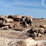
Ian led the EVA accompanied by Peter and Hunter. Curiosity and Opportunity began the day with 291.4 hr and 197.3 hr, respectively, and 100% battery each. We took Cow Dung Road south for the first time ever and arrived at the bend in Cow Dung Road at about 519500E, 4248300N. The team disembarked from the rovers and headed east towards the stream. The tributary we parked the rovers by soon flowed into the main channel that flows north from KCR, which is probably the largest ephemeral stream we have been in! Peter and I took some width measurements while Hunter was taking some samples along a cut bank of the stream. We then headed south in search of some large tributaries Ian planned on taking measurements of. We went up a couple small tributaries, but passed the main one Ian was looking for unfortunately as it blended in as another small tributary (there were quite a few). We kept heading south in search of a larger tributary, but did not find one. Instead, we found a lot of igneous rocks, which is something that was very rare or not present in Candor and Eos Chasma. At our stopping point, where we turned back towards the rovers, we noted that there was an ATV path that led down from Cow Dung Road closer to the main channel for a future EVA. We also saw a great outcrop of many of the stratigraphy exposed throughout the MDRS campus. On the way back to the rovers, we took another stream measurement as Hunter took some Paleosol samples, but both Ian and Hunter think they could get some more data out of the region. When the team returned to the Hab, the rovers were at 291.8 hr and 73% battery (Curiosity) and 197.8 hr 69% battery (Opportunity).
Destination: Main ephemeral stream running south & the tributaries nearby
Coordinates (use UTM WGS 84): drive rovers to 519750E, 4248250N; traveled east to the main ephemeral stream then south as far as 520341E, 4247512N.
Participants: Ian Pamerleau, Hunter Vannier, Peter Zoss
Road(s) and routes per MDRS Map: MDRS driveway, Cow Dung Road south through Kissing Camel Ridge down to the bend in the road going east (about 519750E, 4248250N). Then dismount and walk along the stream south.
Mode of travel: Rovers (Opportunity and Curiosity) & walking


You must be logged in to post a comment.