

[title End-Mission Research Report – February 16th]
[category science-report]
Crew 292 End-of-Mission Report
MANGALYATRI (Mars Explorers)
Mars Society Australia
February 4th – Feb 17th, 2024
Crew Members
Commander: Dr. Annalea Beattie
Crew Science Lead and Geologist: Bharti Sharma
Health and Safety Officer and Crew Biologist: Daniel Loy
Crew Engineer: Rajvi Patel
Green Hab Officer and Geospatial Information Specialist: Mehnaz Jabeen
Crew Astronomer and XO: Aditya Karigiri Krishna Madhusudhan
Crew Journalist and Geo-conservationist: Clare Fletcher
Mission Overview: Planning for Ladakh
Mangalyatri MDRS Crew 292 is a primarily Indian national crew fielded by Mars Society Australia. In the last decade MSA has worked with institutions and organisations in India and elsewhere, to jointly field space science crews to sites in India that have similar conditions to those you might find on planets like Mars. Mangalyatri 292 has an overall focus on what we can learn here from the Mars Desert Research Station, Utah, so that we can build a Science Desert Research Station in the high glacial deserts of the Himalayas, Ladakh, India.
Ladakh is a very cold, very high-altitude desert region, (3500 to 5700 metres above sea level) in the eastern part of the state of Jammu-Kashmir of northern India. Ladakh has lower levels of oxygen in its atmosphere and high levels of UV radiation because of its altitude. It usually receives little rainfall and experiences large fluctuations in temperature between seasons and between day and night. Its glacial deposits and regions, dune and intra dune ponds, hot springs, hypersaline lakes and permafrost regions are high-altitude environments for off-earth analogue and astrobiology research. In this harsh environment, breathlessness and ataxia are common, and it is often difficult to move around. Our expeditions carry oxygen tanks and we travel with a doctor. Presently, there is no dedicated Mars analogue science research station with living quarters, laboratories, and communication services in Ladakh or anywhere else in the Southern hemisphere.
Investigators:
All Crew. The members of Mangalyatri Crew 292 at the Mars Desert Research Station were chosen because of their research interests and secondly, their ability to think ahead to the future for a science desert research station in South Asia. For this rotation, our crew shares this common goal. Keeping this in mind, during our time at MDRS each person has different objectives and tasks aligned to their own field of knowledge, whether it be science, science operations, design, systems in the hab or green hab, art, astronomy or geoconservation. We are all driven by the science, carrying out field science and scientific research to compare different, extreme, terrestrial environments to understand more about the extraterrestrial. Our aim here is to develop frameworks for sustainable analogue research in terms of both science and science operations. We have learnt so much from living and working together in simulation at the Mars Desert Research Station.
For instance, as mentioned in previous reports, our Science Lead Crew Geologist is comparing the geology and geomorphology of both this region and Ladakh which can then be compared with Martian landscapes to identify similarities. Our Crew Engineer is interested in design materials and systems, whether this be power requirements and sizing of generators/ solar panel arrays, toilets and pumping, or interior space layout. In the Green Hab, our Green Hab Officer uses geospatial information to understand how we might establish a greenhouse in Ladakh where natural vegetation grows and survives in winters when temperatures drop to minus 20 degrees. Our Crew Astronomer is formulating comprehensive plans and effective strategies for the construction of an observatory in preparation for the upcoming analogue science station in India. Our Crew Biologist is testing operations using portable scientific equipment to inform protocols and baseline equipment required for future analogue simulation sites, for use by both biologist and non-biologists. Our Crew Journalist uses their geoconservation research to better understand how a proposed Mars analogue station in Ladakh could implement geoconservation practices from its inception. As Artist-in-residence here at MDRS, my role is to think through drawing to broaden our understanding of how we live and work together in simulation. I’m interested in how we imprint onto land that is not our own and how, by using art making as a methodology, we can develop an ethics of reciprocal responsibility, one that can be translated to elsewhere⎯to Ladakh⎯and when we travel off-Earth to Mars.
Current status:
Please see individual research reports for progress.
EVA’s:
All our field work has contributed to this project.
Exploring Planetary Analogue: Deciphering Geomorphometric and Slope Analysis across Analog Environments
Investigators:
Bharti Sharma in collaboration with Clare Fletcher (CREW 292), Mehnaz Jabeen (CREW 292), Dr. Annalea Patricia Beattie (CREW 292), Daniel Loy (CREW 292), Dr. R. P. Singh (University of Allahabad), Dr. Jonathan A. Clark (Mars Society Australia) and Prof. Colin Pain (Mars Society Australia)
Overview:
The goal is to measure the slopes of the outcrops, create a geomorphological map of the region, conduct geomorphometric analysis, and understand the processes that produced the region. And compare it to the slope angles and geomorphometry of Ladakh. This research helps us comprehend the terrain and provides insights into the geology and geomorphology of the region, which we can then compare to the Martian landscape to detect parallels.
Throughout the geological history Utah has undergone a wide range of environmental conditions including submersion beneath the ocean and inland seas or completely desert terrain. The topography has seen substantial variations, fluctuating between sea levels and exceeding an altitude of two miles. The terrain has experienced periods of relative flatness, alternating with periods of characterized by the uplift of mountains and the formation of valleys.
So far, no extensive geomorphometric investigation of Hanksville has been conducted. Geomorphometry is the study of quantitative land surface analysis. It developed directly from two fields that had their roots in geometry, physical geography, and mountain measuring in the 19th century: geomorphology and quantitative terrain analysis. Modern geomorphometry focuses on the refining and processing of elevation data, the description and display of topography, and a wide range of numerical computations. It focuses on the continuous land surface, although it also considers landforms and discontinuous features like watersheds. The operational purpose of geomorphometry is to extract measurements and spatial information from digital topography. Geomorphometry has several uses in Earth science, civil engineering, military operations, and entertainment. Five phases are often included in geomorphometric analysis: sampling a surface, creating and adjusting a surface model, figuring out land-surface parameters or objects, and using the findings. Landforms and point measures, such as slope and curvature, are included in the three types of parameters and objects. Fundamental spatial units with uniform attributes are called landform elements. Complex analysis might include non-topographic data and many variable maps. The neighbourhood operation is the process used to recover the majority of land-surface data and objects from a digital elevation model (DEM). No DEM-derived map is authoritative since parameters change with geographic scale and can be created by various algorithms or sampling procedures.
A total of 6 EVA has been conducted so far get to the ground data from the field. First EVA was a training EVA, to get accustomed to the suit and Rover. Second and Third EVA was done to get the data from Cow Boy Corner. Location point has been collected from the site for different types of weathering, structural features such as cross bedding, rock type classification, general geomorphology to understand the chasm, meandering of river channel and ridges in the region. The fourth EVA was carried out on Kissing Camel Ridge’s western side in order to estimate the slope from the bedding plane. Three measurements of the dip and strike have been obtained from the Kissing Camel Ridge. It was challenging to quantify dip and strike since the majority of the surface in the area has worn and eroded away from the parent rock. The locations of the fifth EVA were Compass Rock and Candor Chasma. The field data includes the kind of rock, the weathering patterns, and the different landforms such as buttes, canyons, paleo-river channels, mesas, and caves. SRTM DEM has been used to create a basemap. The research area’s comprehensive geology and the literature review has been written. Geomorphometric analysis of Tso Kar, Ladakh, has already been completed. To comprehend the stratigraphy of the area, the Litholog has been developed form several sites.
For analysis, the following fundamental morphometric variables will be used: slope, altitude, aspect, topographic profiling, northwardness, eastwardness, plan curvature, horizontal curvature, vertical curvature, difference curvature, horizontal excess curvature, vertical excess curvature, accumulation curvature, ring curvature, minimal curvature, maximal curvature, mean curvature, Gaussian curvature, unsphericity curvature, rotor, Laplacian, shape index, curvedness, horizontal curvature deflection, vertical curvature deflection, catchment area, dispersive area, reflectance, insolation, topographic index and stream power index. In addition, the hypsometric curve analysis will be done using Landsat data in ArcGIS to understand the erosional and depositional history. Furthermore, the Land cover classification will use Eolian Mapping Index to distinguish land cover types such as sand cover, stone covered sand, rock surfaces and vegetation.
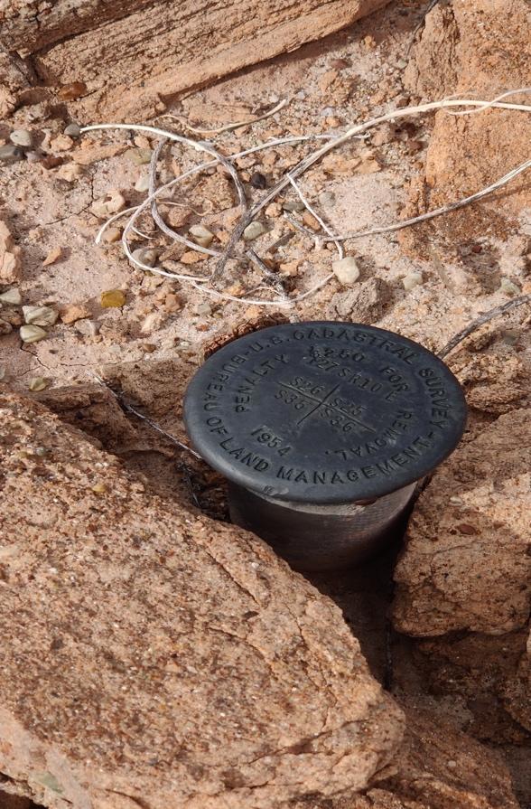
Survey benchmark Hanksvile, Utah, USA
Title: Understanding frontier environments through drawing
Investigators:
Dr. Annalea Beattie, with full crew participation.
Objectives:
Through art making, this project focuses on boundaries, thresholds and environmental stewardship. It speculates on how our position in an unknown landscape and through immersion in art, what might constitute a compositional approach to understanding and caring for a ‘frontier environment’. This research project invites our crew to participate in an act of examination, exploring through drawing and painting territory beyond the boundaries and borders we create for ourselves as humans in an unfamiliar, non-human landscape.
Current Status:
Crew 292 have been provided with sketchbooks and drawing materials and a working studio table has been set up in the Science Dome in front of the large horizontal window to the desert. Materials such as paper, brushes, watercolours, watercolour pencils, graphite sticks and carbon powder are laid out and I am in regular studio attendance. At our project meeting on Sol 2, I explained my research and that I am available to collaborate. Our crew is aware of how art making crosses disciplines, how it can create a low-stake environment to experiment, and more importantly for off-Earth communities, how it creates a safe place to fail. I invited our crew to use their journals and to paint and draw something from their discipline or experience that might extend their understanding of this simulated environment. Or something that might help them explore the future.
To date, almost all our crew have used drawing and/ or painting to reflect upon their position in this desert landscape, situating art making as alternative knowledge in our small space in a vast space. Our astronomer Aditya has drawn the magnitude of celestial light he can see in our dark sky. Green Hab Officer Mehnaz has begun to draw the future – breathing life into barren planets through drawing a vision of the Green Hab for spacefarers living off-Earth. In relation to the science field work, the techniques and strategies of drawing already belong to geology. Observation in the field is a primary means of obtaining scientific knowledge for planetary field science. Geologist and Science Lead Bharti Sharma and I drew geology together in the field on EVA #10 at Kissing Camel Ridge. We both will work on the lithologic log for her comparative study of different kinds of deserts; Ladakh, here in Utah, and deserts on Mars.
When it comes to drawing, geologists recognise that there is a virtual or abstract dimension in perception that is always dynamic. They bring their experiences and prior patterns of sensorimotor perception to the context of field drawing, for instance, as part of their lived relation to the subject. This might mean, for example, that when geologists see surface or texture, they intuit depth, volume and weight. Drawing is inferential. We think through materials to potential in imperceptible and unfamiliar qualities of form, not just as flat, inert surfaces. The deliberate practice of geological field sketching in simulation is a sustainable method of gathering of data during field work.
Crew Journalist Clare Fletcher spent time at the drawing table set up in the Science Dome, drawing and painting rock samples removed from the desert. Clare is a geoconservationist and her project here focuses on the practicalities of efficient and sustainable sampling. Drawing samples is a useful way of thinking through materials to inference and hypothesis. These samples have been returned to the site on our last day here at MDRS. I also have spent time drawing rock samples in the Science Dome, drawing basalt, concretions, gypsum, and the sandstone weathering. This experience of drawing rocks is generative. As I draw, I engage with what has happened here in this landscape and why this desert is a geological analogue for Mars.
When we travel off-Earth to Mars we will be confined by the lethal atmosphere, a lack of physical space, and a utilitarian regime that keeps us alive. When it comes to understanding how life might be in an enclosed community in extreme environments on Mars, I am always thinking about the role that the techniques and strategies of art will have in the long-term growth of small micro-societies living in adversity in space. Art making is a socially engaged practice that belongs to everyone. It builds rich, diverse communities and shares meaning as it makes its own place amongst other disciplines as part of ordinary life in simulation. This research project is improvised, long-form and ongoing. Its results are not easily quantified nor is it data driven yet there is no doubt that art making in this confined context has potential to shift our perceptions and the capacity to affect change.
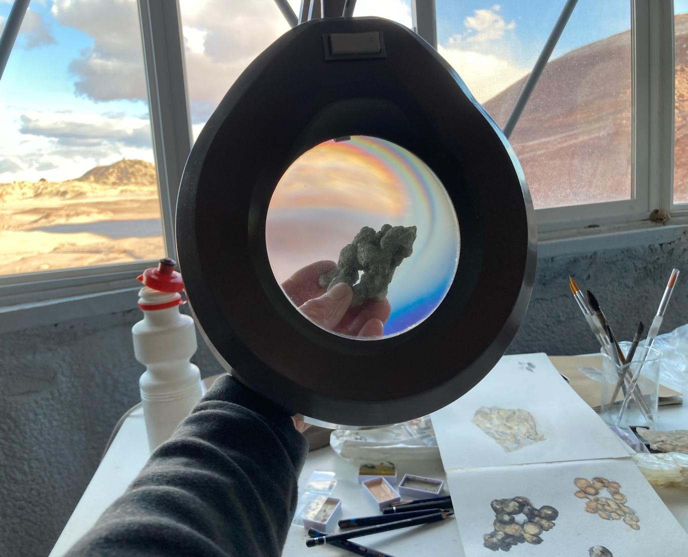
Drawing concretions in the Science Dome, 12-02-24
Investigating the Thermo-hydrological Dynamics of Green Hab: A Comprehensive Study on the Impacts of Temperature and Humidity on Evapotranspiration
Investigators:
Mehnaz Jabeen in collaboration with 292 crew member, Aditya Karigiri Krishna Madhusudhan
Professor: Vinay Shankar Prasad Sinha, Central for Study of Regional Development, School of
Social Science, JNU University, Delhi
Senior Water Engineer: Himani Singh, William Sale Partnership, India
Overview:
Hydrological processes and requirement of crops have been greatly impacted by climate change at global, regional, and local levels. Climate change is observed to be directly related with increase in the surface temperatures. In hydrological cycles, precipitation and evapotranspiration are largest components of water balance. In hydrological cycles, actual evapotranspiration (AET) and potential evapotranspiration (PET) plays a significant role specifically in evaporation of soil and crop transpiration which eventually affects productivity in crops. AET is the actual amount of evapotranspiration (ET) on the surface that is controlled mainly by these two processes of evaporation from the soil and transpiration from the leaves. PET is the rate at which maximum amount of water loss as vapor into the atmosphere by a vegetation cover when there is access to surplus amount of water supply. PET is calculated from atmospheric factors such as air pressure, solar radiation, wind speed, temperature, and relative humidity. Changes in these factors lead to changes in PET. PET takes higher value than AET, however with access to unlimited amount of water AET can be equal to PET. PET significantly impacts the availability of water resources as a result affecting agriculture productivity. Thus, estimation of PET is significant to assess the impact of changes in atmospheric variables on atmospheric evaporative demand, balance in hydrology of the ecosystem, response, and interaction of vegetation to the climate.
On the context of the above, manipulated atmospheric variables in a controlled environment compared to natural environment can be shown pivotal to easily study and access the impacts of changes and estimation of PET, maximizing plant growth and resource efficiency. Therefore this research aims to delve into the thermo-hydrological dynamics within the controlled ecosystem of Green Hab, specifically focusing on nuanced interplay between temperatures, humidity, evapotranspiration (ET).
Objectives:
Explore the spatial and temporal variations of temperature, humidity, and soil moisture within the Hab and different climatic environment within MDRS (artificial ecosystem).
Rigorously assess the effects of manipulated temperature and humidity conditions on evapotranspiration dynamics.
Employ climatic datasets from the nearest climate centers.
Calculate Actual Evapotranspiration (AET) and Potential Evapotranspiration (PET) through established equations.
Apply the Budyko curve to decipher the ecosystem’s response to altered temperature and humidity regimes.
Current Status:
Obtained datasets the LOA Climate Center, Utah.
Data cleaning and processing.
Performing Pan Evaporation experiment to estimate evapotranspiration rates at different temperatures.
Performing experiments with newly sown seeds in similar pots with equal weights to study the effects of varying temperature on plant growth.
Developing machine learning model to predict the evapotranspiration using the datasets collected.
Data Collection:
Establish a baseline by conducting continuous, high-frequency monitoring of temperature, humidity, and soil moisture to capture diurnal variations.
Design factorial experiments introducing controlled variations in temperature and humidity.
Obtaining climatic datasets from nearest climatic centers for open air natural environment.
Implement a meticulous sampling strategy, aiming for daily data acquisition during experimental perturbations.
Evapotranspiration Calculations:
Employ the Penman-Monteith equation, incorporating real-time and 8 years of meteorological data from the advanced sensors, to compute Potential Evapotranspiration (PET).
Derive Actual Evapotranspiration (AET) through meticulous monitoring of soil moisture dynamics; integrating fluxes from both soil and vegetation components.
Validate computed PET against established literature values and meteorological data to ensure model accuracy.
Implement machine learning algorithms for refining ET predictions based on observed data, enhancing model precision.
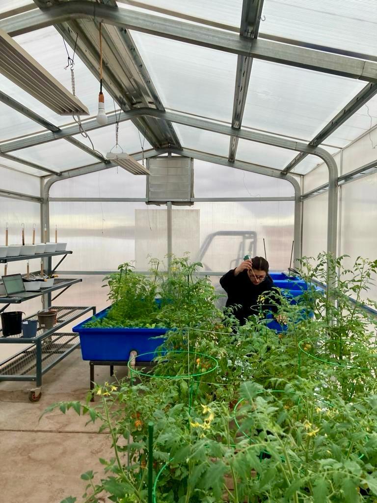
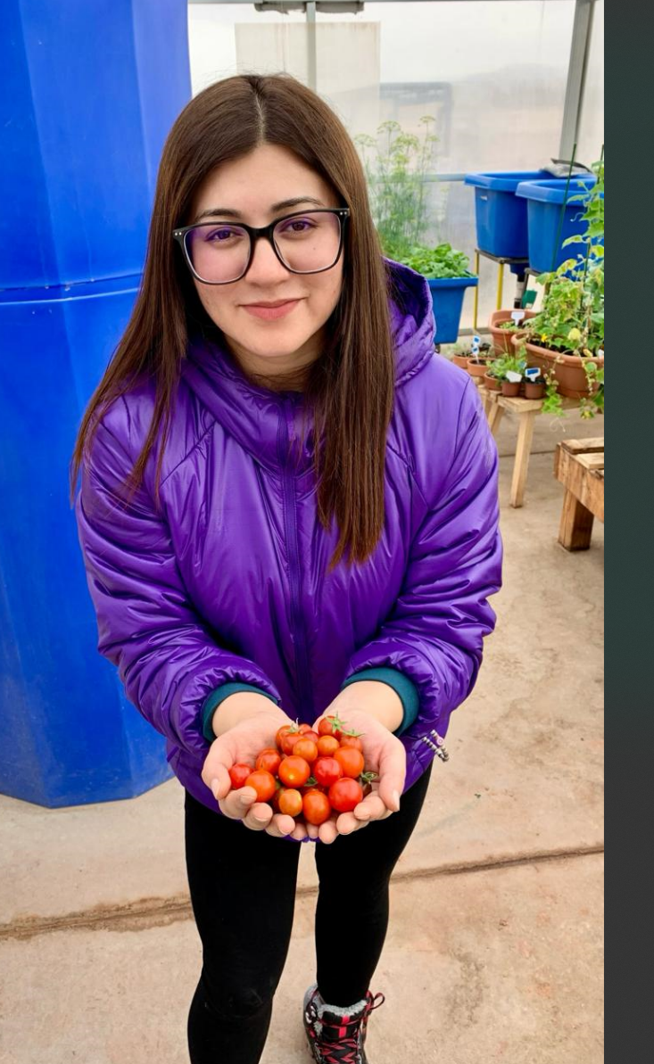
Figures above: our Green Hab Officer Mehanz Jabeen in the Green Hab measuring the temperature of the crops and with the cherry tomato harvest.
Expected Outcomes:
Identification of critical thermo-hydrological thresholds influencing evapotranspiration dynamics.
Enhanced spatial resolution in understanding micro scale variations within the artificial ecosystem
Rigorous validation of the Budyko curve as a tool for assessing water balance under controlled environmental conditions.
Significance:
The technical rigor embedded in this research will not only contribute to our fundamental understanding of controlled ecosystem dynamics but will also provide precise insights into optimizing temperature and humidity parameters for enhanced plant growth and resource management in artificial habitat especially in Ladakh (India) with extreme climate conditions and Mars-like terrain.
Investigating the use of portable laboratory equipment in a Martian analogue research station
Investigators:
Daniel Loy, with collaboration from all of crew 292. PhD Supervisor: Dr Michael Macey, The Open University, Walton Hall, Milton Keynes, United Kingdom, MK7 6AA
Objectives:
To conduct scientific operations research on the use of portable equipment in an analogue environment, carrying out DNA extractions, PCR and gel visualizations with the Bento Lab portable PCR workstation. This is a combined portable centrifuge, PCR machine and gel imaging station and will be used in conjunction with a MoBio DNA extraction kit, which has been used by previous crews. This project will consist of cultivation-dependent and independent DNA extraction from samples gathered in the Martian analogue environment surrounding the Mars Desert Research Station (MDRS).
Collected samples will be inoculated into a range of extremophile media with any visible growth having DNA extractions performed on them. Extractions will also be carried out directly from gathered samples. Non-targeted PCR will initially be performed to identify if DNA is present from both sources, with ID and functional gene PCR’s being run on positive samples. This can then form the basis for a training framework and protocols that could be carried out by non-biologists at both the MDRS and future India analogue research station.
Current Status:
Samples were collected by multiple crew members during across different EVA’s to carry out direct DNA extraction as well as attempt culturing, listed below. The coordinates given are in Universal Transverse Mercator (UTM) format, location WGS 12S.
Table 1. List of Samples/Cultures that had DNA extraction performed on them.
|
Name |
Type |
Sol, EVA and Location |
|
L |
Lichen |
Sol 4, EVA 4 N4253168, E518918 |
|
G |
Green Mudstone |
Sol 4, EVA 4 N425376, E518972 |
|
S |
Soil under rock |
Sol 4, EVA 4 N4253311, E518982 |
|
WA |
Water |
Sol 6, EVA 7 N4251004, E518556 |
|
WB |
Water |
Sol 6, EVA 7 N4251131, E518493 |
|
S1 |
Soil |
Sol 7, EVA 8 N4252848, E518615 |
|
S2 |
Soil |
Sol 7, EVA 8 N4252922, E518410 |
|
C |
Soil from eroded crevice of rock |
Sol 8, EVA 9 N4249486, E518361 |
|
Y |
“Yellow goo” found in small body of water |
Sol 8, EVA 9 N4249488, E518287 |
|
Y2 |
“Yellow goo” found in small body of water, repeat extraction of above sample |
As above |
|
YSP |
“Yellow goo” inoculated in 1:10 dilution of SP media |
As above |
|
SSP |
Soil under rock inoculated in 1:10 dilution of SP media |
Sol 4, EVA 4 N4253311, E518982 |
|
SRN |
Soil under rock inoculated in RN media |
As above |
DNA extractions were carried out from 0.25 grams from each sample, or in the case of liquid samples/cultures 200ul of liquid after being agitated by hand for 10 seconds. The Mo Bio DNEasy Powersoil Pro Kit Extraction protocol was followed for all extractions, with hand mixing being used to lyse and mix during the process, as no vortex was available.
DNA was successfully extracted from two soil samples collected on different EVA’s from different sites, these are highlighted in bold in table 1.
Using targeted PCR, Archaea and Fungi were identified to be within the soil in both S and S2 samples. The S soil sample also contained Bacteria, while this could not be identified within the S2 sample due to an amplication failure. The presence of functional genes was also investigated with the large subunit gene hhyL of the group 1h [NiFe]-hydrogenases found within both soil samples, and the sulfide:quinone oxidoreductase gene fragment sqr was found within the S soil sample.
Roadblocks:
As there was no vortex or other shaking equipment available to agitate samples and lyse cells as the first part of the DNA extraction protocol, they had to be shaken by hand. The initial vortexing was meant to last 10 minutes so samples were shaken by hand for 12 minutes due to the difference in speeds. This difference may have been the reason why less DNA was found than expected from some samples and the cultures.
Future Prospects:
The successful extraction, amplification and visualisation of DNA and specific genes with this equipment shows that portable laboratory equipment can be used in Martian analogues to investigate the presence and functions of microorganisms in other extreme environments. Pre-existing protocols for all processes were followed, meaning anyone, including non-biologists, with the right equipment would be able to replicate these methods including at the proposed Ladakh analogue research station.
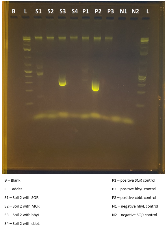
Image description: Image of an electrophoresis gel showing the results of a PCR test investigating the presence of functional genes in Soil 2. The positive result in S3 shows that the hhyL gene is present in the microbial community present in the soil sample.
Title: Looking through the eyes of telescopes and exploring the wonders of our cosmos
Investigators: Aditya Krishna Karigiri Madhusudhan (Crew Astronomer) and Peter Detterline (Director of MDRS Observatories)
Overview:
Mission 292 of the Mars Desert Research Station (MDRS) focuses on gaining valuable experience and knowledge to develop a Mars Science Analog Research station in India. The central objective is to formulate comprehensive plans and effective strategies for the construction of an observatory in preparation for the Ladakh station. A critical aspect of the observatory’s success is selecting the right telescope optimized for the weather conditions in India. Studies have been carried out to identify telescopes with optimal solar and deep sky observation capabilities while withstanding varying climatic challenges. The telescopes are being chosen such a way that they offer precision, high-resolution imaging, and compatibility with local weather patterns. To safeguard the chosen telescope and observation equipment, a weather-resistant dome is being designed using Fusion 360 software. The dome’s design is planned to incorporate features such as insulation, ventilation, and stability to ensure reliable and uninterrupted observations despite the weather conditions. To ensure the safety of astronauts during Mars missions, understanding and monitoring solar radiations is crucial. Despite the availability of ground support warnings, the necessity for an independent solar observation system cannot be overstated. In addition to developing plans to build an observatory, the secondary objective is to make use of the Musk and robotic observatory, a specialized facility designed for solar and celestial object observations. As the crew astronomer, I conducted several observations utilizing the MDRS and RCOS robotic observatory to capture and analyse celestial objects and events. This endeavour will contribute to a deeper understanding of our universe and its implications for space travel and exploration.
Objectives:
To conducted astronomical observations using the MDRS WF and RCOS 16 telescopes and carry out solar studies using the Mush observatory at MDRS.
Develop plans and strategies to construct an observatory at Ladakh.
Current Status:
1. Conducted astronomical observations of AG DRA and conducted photometric analyses to determine the variable star’s brightness. The star is observed to be much fainter than it should be. Hence further photometric measurements at various filters are to be conducted.
2. Observed NGC 5904 (Globular cluster), NGC 281 (Pacman nebula), M51 (Whirlpool galaxy) and NGC 1952 (Crab Nebula) using various filters to explore the wonders of the cosmos.
3. Currently analyzing sky conditions and visibility at MDRS, to plan the construction of an observatory in Ladakh. Researching telescopes from dealers like Celestron and Orion that are suitable for Ladakh’s skies. Planning to make a preliminary design of the dome required to cover the telescope using Fusion360 CAD software. Also, reviewing the current observatories present in Ladakh to understand its functionality and usage.
4. Participated in 6 EVA’s (one for training and 5 for geological study and sample collection) which helped me understand the landscape of MDRS. This knowledge can be used in selecting the optimal site for deploying an observatory in Ladakh.
Roadblocks:
Unfortunately, the Musk solar observatory has been offline during my mission at MDRS. This has restricted me to do any solar observations.
During the second week of the mission, the RCOS 16 telescope has been down with a failed WCS registration. Hence, no further photometric observations could be carried out.
Outcomes:
Extensive use of the MDRS WF telescope was carried out to perform astrophotography. The images obtained are attached below.
Studies on possible observatory design and essential components required are carried out. More work on this part will be carried out after the mission and will be updated.
Given my training on the MDRS telescopes, I will still be able to access them after my mission. Hence, more images on interesting celestial phenomena will be conducted and shared to Mars Society.
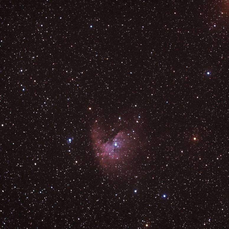
The following image is taken through the MDRS WF telescope, processed using AstroImageJ and Photoshop software. Below : NGC 281, Pacman Nebula in the constellation of Cassiopeia, 9500 light years away (10-02-2024)
Title: Developing a method of simultaneous Mars exploration and
exogeoconservation in the Mars Desert Research Station
Investigators:
Clare Fletcher, with help from Crews 291 & 292, MSA, and TMS. This project is part of a PhD undertaken at UNSW, in the Australian Centre for Astrobiology, supervised by Profs. Martin Van Kranendonk and Carol Oliver, and funded by the Australian Federal Government’s Research Training Program.
Objectives:
Conduct fieldwork to attempt to find both previously noted sites of and predictive work regarding outcrops of gypsum, concretions, petrified wood samples, and possible microbial samples. Identify geological and geomorphological sites that might be conserved to provide a comprehensive suite of geoconservation for the area and understand how this would apply to Mars and its exploration. Quantify both human and environmental impacts over the last ~20 years of the MDRS.
In collaboration with Crew 292, this project will be used to better understand how a proposed Mars analogue station in Ladakh could implement geoconservation practices from its inception as part of the ethos, values, and protocols of the proposed analogue station.
Current status:
Previously noted field sites have been (mostly) found, though there were some that could not be found due to time and/or weather constraints. Some were deemed less critical as predictive work was done that covered some of the values. Predictive work was undertaken to attempt to correlate predetermined conservation targets with certain landforms and locations, which was done with varying levels of success. Key geological and geomorphological features have been identified for their suitability as geoconservation sites (that still allow exploration and science), however, these sites can and should be updated if more information is learned that indicates more suitable sites. Human impacts have been quantified as low. Environmental impacts have been partly quantified, based on work done by previous MDRS crew member Henrik Hargitai, however 4/5 sites identified by Hargitai were inaccessible to our crew while in sim and therefore could not be studied. Samples that were taken during 291 and 292 have been returned to either their original location or to a location with the same features and outcrops. Samples that had been left in a basket from previous crews were sorted based on their geology and also returned to suitable locations.
Preliminary Findings:
Broad geology and geomorphology can be easily understood remotely ahead of time; however, this work is predicated on other field studies having taken place. While remote sensing may be able to give some understanding of geology and geomorphology, it was found during this study that that understanding can often be incorrect, as evidenced when in the field. Some key features and/or sites may be identified for geoconservation purposes remotes (e.g., major structural features, some modern processes, some representative surface features, some records of past environmental conditions). However, during this study it became clear that identifying stratotypes, formation of minerals, evolution of life, some modern processes, some representative surface features, and some records of past environmental conditions must occur in-situ. Equally predicted key features often turned out to be less important when in-situ, and other features became more useful and more ingrained into the crew psyche. The samples taken felt like important samples to take when on an EVA, however, many were never looked at again in the Hab and/or lab. Those that were looked at closer when back at the Hab and/or lab were more cryptic in the field and needed the additional study (e.g., chert vs. petrified wood). Given more time on EVA’s, and the inclusion of at least one geologically knowledgeable or trained person, better characterisation of various rocks and minerals could take place in the field, meaning that less samples would need to be taken from the field. Even with a good understanding of the geology and the features or samples you are looking for, predicting where you will find them is extremely tricky, and gets trickier proportional to the decrease in scale of the feature/sample. This means that both conservation and sampling and made more difficult as if one happens before the other, the other may never come to fruition. Conservation and sampling during exploration and for scientific purposes needs to occur concurrently. Detailed mapping of the area to avoid issues with prediction of the geology, geomorphology, small-scale features for sampling, etc. is impossible in sim. The roads, rover charge, suit mobility, and time constraints all hinder detailed mapping while in sim, and detailed mapping occurring out of sim would not be true to the Mars experience that is key to the analogue experience at MDRS. No matter what a single crew does, there are years of crews before and will be years of crews to follow that will treat the landscape differently. There is nothing inherently bad (or good) about this, but it means that what each crew learns about and sees in a site will be different from previous crews, even if identical procedures were followed.
Lessons learnt to be applied to Ladakh:
A detailed mapping of the geology, geomorphology, and biology (both extant and past) should be undertaken by a team of individuals with expertise in all the above fields as well as one to multiple people who are experts in (geo)conservation practices. This will give a detailed and accurate baseline for the site against which everything else can be measured.
If an analogue station similar to MDRS is to be set up in Ladakh, an emphasis could be placed on ensuring every team has an environmental scientist and/or (geo)conservationist. A few key sites should be identified to monitor both environmental change and anthropological change over time, however, they should all be easily accessible at all times of year with multiple types of vehicles (including the possibility of walking there, meaning they must be within the walk-back distance).
Key features for geoconservation should be identified prior to the construction of a research station and crew rotations beginning. This establishes a precedent for what features to be mindful of at varying scales (and accounts for variations between crews identifying different features as more or less important, and the landscape changing with successive crews). A guide to field sampling and practices rooted in both geology and geoconservation should be created prior to beginning crew rotations and all crew members should have early access to it, have a copy at the station, and sign in agreement with the sampling and field practices, meaning all crews have equal opportunity to conduct analogue fieldwork, but can also enjoy field sampling and fieldwork broadly.
EVA’S:
EVA #1 Training EVA. EVA #7 to the Hargitai “White Mushroom Field” (between Marble Ritual and Pooh’s Corner but on the northwest side of the road, by the MDRS maps). EVA #8 to a palaeochannel south of Cowboy Corner. EVA #9 to Kissing Camel Ridge East. EVA #11 to Candor Chasma. EVA #13 to return samples from the Hargitai “White Mushroom Field” (between Marble Ritual and Pooh’s Corner but on the northwest side of the road, by the MDRS maps) and from to the east of the road partway to Phobos Peak. EVA #14 to return samples from the dry creek crossing on Cow Dung Rd north of Cowboy Corner, as well as samples from Cowboy Corner.
Title: Propellant production at MDRS using water-bearing and carbonate rocks
Investigators:
Crew Engineer Rajvi Patel in collaboration with Bharti Sharma, Clare Fletcher, and Andrew Wheeler (Crew 291).
Overview:
This project is focused on the production of rocket propellant methane utilizing the resources available on the Martian surface to make interplanetary travel self-sustainable. One potential water source on the Martian surface is water-bearing minerals like Gypsum (CaSO4.2H2O) and Epsomite (MgSO4.7H2O) that hold chemically bound water and are often associated with evaporate deposits in arid areas on Earth and Mars.
The Martian atmosphere comprises 95% carbon dioxide in its atmosphere and accessible CO2 in the polar ice caps. Other sources of CO2 are dust particles in the Martian soil and carbon locked in mineral deposits, which is utilized here for this research. The landscape of the Mars Desert Research Station (MDRS) near Hanksville, Utah contains a variety of concretions, developed in poorly cemented medium to coarse channel sandstones and are formed during burial. These concretions tend to weather out of the rock as they are more indurated than the surrounding sandstones. During this process, the surface of the concretions acquires a purplish or brownish color, suggesting traces of manganese and iron in the carbonate. Hematite concretions have been found on Mars to date. Therefore, this mission included a collection of Gypsum samples and concretion samples as sources of water and carbon dioxide required to produce methane.
Objectives:
Determine a process to generate methane (CH4) from water (H2O) and carbon dioxide (CO2).
Current Status:
This research was performed at MDRS in a simulated Mars environment with Crew 292 Mangalyatri. During a simulated Extra Vehicular Activity (EVA) at the corner of Brahe Highway and Cow Dung Road, Crew 291 collected a sample of efflorescent gypsum. On another EVA to Candor Chasma, I was able to collect two different samples of gypsum on 292– authigenic bedded gypsum (Type 2) and selenite gypsum (Type 3).
Preliminary analysis will be performed on them to validate if they release water or not at elevated temperatures.
Three types of concretion samples were collected as a part of EVA’s on this mission. While on an EVA to Kissing Camel Ridge, samples of dark concretions in the dark matrix (Type 1) were collected. Light concretions in the light matrix (Type 2) samples were collected on a simulated EVA to Dry Creek Bed. EVA to a location between Pooh’s Corner and Marble Ritual led to a find of Type 3 concretions which were dark in the light matrix. Preliminary analysis was performed on these samples to check if they released carbon dioxide when reacted with vinegar. All three confirmed the carbon dioxide release.
As a part of my future work, hydrogen can be produced from gypsum water using electrolysis. Then, hydrogen can be reacted with carbon dioxide which will result in the production of methane using the Sabatier process.
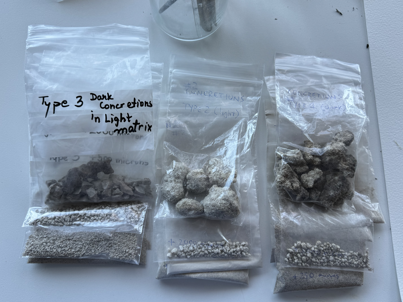
Figure 1: Types of Concretions validated for CO2 release
Title 2: System requirements for the Ladakh station.
Investigators:
Rajvi Patel in collaboration with the whole Crew 292
Overview: This project is focused solely on preparing a requirements plan for the systems needed for the Ladakh research station. This research includes the study of power systems, heating systems, water, and fuel systems at MDRS.
Mars Desert Research Station (MDRS) is comprised of six structures.
The Habitat (Hab)
The Musk Observatory (now called as Solar Observatory)
The Robotic Observatory
The Green Hab
The Science Dome
The Repair and Maintenance Module (RAMM)
Objectives:
Generate a preliminary systems requirements layout for the Power and Heating systems at the Station in Ladakh.
Current status:
Power System:
The whole campus is powered by a 15kW solar panel system which feeds the 12kW battery bank. There is a 14kW generator that autostarts when the campus uses more power than the solar can provide.
Primary Power System: Solar panels
Secondary Power System: Propane Generator
Working of the Power System:
Solar panels (x45) supply power to the charge controllers which feed the 12kW battery bank. Batteries provide power to the inverter delivering AC power to the Habitat. The default for batteries on the systems is 75%, but we decided to go with 80%. Once the SOC (state of charge) goes below 80%, the generator is expected to start automatically. This system of autostart doesn’t work so it is operated manually.
The remote access modem to the power control system has been relocated from the upper deck to the Robotic Observatory. It is a small powered black box that should never be unplugged.
Heating System:
Heating for the Hab: The main source of heat for the Hab is a forced air propane heater located above the shower room and bathroom. It is a Carrier Comfort 80 Low NOx Gas Furnace.
https://www.carrier.com/residential/en/us/products/furnaces/58sb1/
Hot water is produced from a 6-gallon propane RV water heater located above the rear airlock on the lower deck. The toilet is a porcelain RV model with a foot pedal for flushing. There is a holding tank below the toilet that must be emptied daily. It has a sensor system indicating the capacity reached by the holding tank and the time to empty it.
Secondary heating for Lower Hab: There is a second wall-mounted ductless propane heater on the lower deck for when temperatures get really low or if the power goes out.
Heating for Green Hab: It has a propane heater and a wall-mounted cooler unit which provides cool air by using the evaporation of water across fans.
Heating for Science Dome: It has a dual split heater/AC. This unit is installed for the protection of the power system’s batteries.
Water system:
There are three different water tanks. The 550-gallon static tank supplies water to the Hab. There is a separate 300-gallon tank in the GreenHab that is used to water the plants and is not connected to the Hab water system in any way. There is an additional 550-gallon water tank at the Outpost for staff.
The water to be filled at the Hollow Mountain and transferred to the Hab by the crew. This static tank water is pumped in the Hab for crew use. The water pump is placed above the rear airlock removing most of the contamination from the system and allowing minimum water to be used without pumping at night. If the water gets below a certain level, the pump still pressurizes the system until it is permanently damaged. The solution to this problem is in progress.
Fuel System:
Propane for the Hab and GreenHab is in a 1000-gallon tank. The pressure gauge is located underneath the metal top cover.
There are four propane tanks on campus, all but one located in the vicinity of the Outpost. The Hab and GreenHab are serviced by the 1,000-gallon tank, while each of the two fifth-wheel trailers in the Outpost is serviced by separate 250-gallon tanks. The pressure gauge is located underneath the metal top cover. The final tank services the propane generator outside the Science Dome. Propane is delivered by Blackburn Propane in Bicknell. Propane powers our heating systems, water heaters, stoves, and the generator. Generator oil, Car oil and supplies are kept in the RAMM.
This is a basic study of these systems at MDRS. As a part of future work, a detailed systems plan will be prepared for the station in Ladakh.
Acknowledgements
Crew 292 closes this mission and this report with a big thank you to everyone who has supported us. We want to personally thank Mars Society Australia for fielding this crew, especially Mars Society Australia’s President Dr. Jon Clarke for his science support and MSA Treasurer Guy Murphy for his ongoing communications assistance. We thank the MSA board and all the members of Mars Society Australia.
Thank you to our External Directors and our supporting academics, to Dr. Siddharth Pandey from Fugro Australia, also an MSA Director, Dr. Jennifer Blank NASA astrobiologist, who is affiliated with Blue Marble Space Institute of Science, Dr. Anushree Srivastava from the Carnegie Institute for Science, Washington, Dr. R. P. Singh from the University of Allahabad, Dr. Michael Macey from Open University, United Kingdom, Prof. Martin Van Kranendonk, Curtin University, Prof. Carol Oliver, University of New South Wales. All of you have helped us and we are very grateful for your ongoing care and interest.
To our Media and Outreach Officer in Jaipur, India, thank you Sakshi Sharma for your fantastic outreach interview with us mid-mission and for your love of space and your energy and enthusiasm for our crew.
Thank you too to those who contributed to funding us: The Mars Society, Mars Society Australia, Open University, United Kingdom, The Centre for Astrobiology, University of New South Wales, the Australian Federal Government for their Research Training Program funding, the Ladakh Autonomous Hill Development Council and Ladakh Science Foundation, Applied Microbiology International (AMI), and the Central England NERC Training Alliance (CENTA).
We thank Commander Andrew Wheeler and the crew members of MDRS Crew 291 for their support and we will continue to collaborate with them in the future.
We thank our family and friends at home on Earth for all their patience, love and care.
Finally, we are very grateful to The Mars Society, to Dr. Robert Zubrin, Dr. Shannon Rupert, MDRS Director Sergii Lakymov and all the Mission Support Team at the Mars Desert Research Station.
On to Mars, Mangalyatri.
Dr. Annalea Beattie
Commander, MANGALYATRI, Mars Desert Research Station Crew 292
Mars Desert Research Station, 16th February 2024