
Crew 261 EVA Report 06-05-2023
EVA # 9
Author: Erin Kennedy (Crew Roboticist), (with inputs from HSO Audrey Derobertmasure)
Purpose of EVA:
1) Testing of Atmosphinder prototype mechanised wind sails and improved towing method
2) Testing of Atmosphinder prototype descending hill with steeper grade
Start time: 11:27 am
End time: 1:50 PM
Narrative:
Overview of EVA
Prior to EVA-9, the EVA crew members were given a briefing on the objective of today’s Atmosphinder experiments and the procedure.
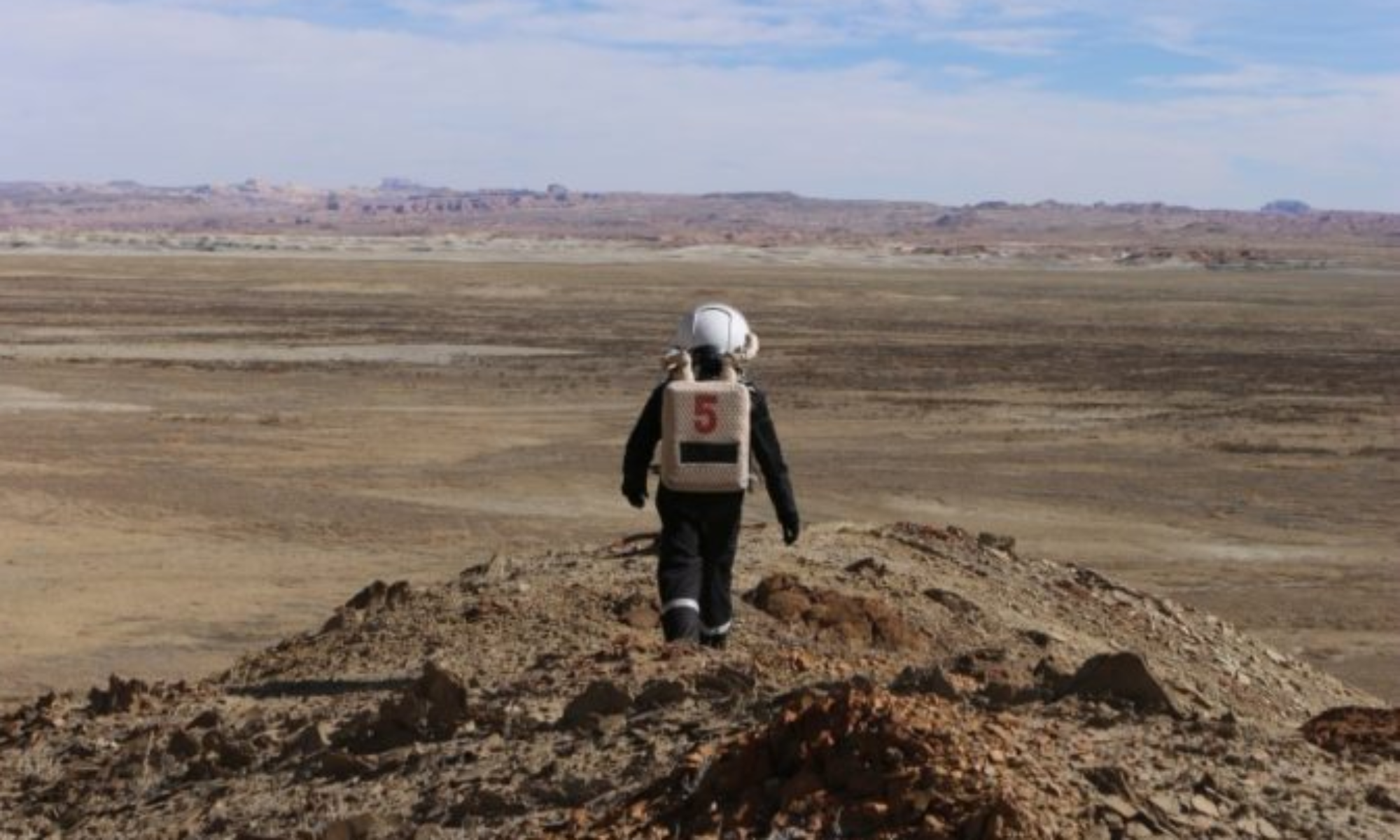
EVA-9 conducted Atmosphinder testing in the half-sized configuration (~1 m diameter) with sails (17″ x 28.5″) extending from the two hoops. The electronics were updated to include one sail trimming servo motor on each sail, and lights to indicate the trim position. The testing was divided into two sections: sail testing near the Hab and steeper grade hill testing near Phobos Peak. The robot and supporting parts were extracted from the RAM.
Sail testing took place in front of the Hab. The sail testing observed the performance of the trim motors with the gusts of wind. In all 3 positions and on both sides, the motors performed to specification. The force of the wind on the sail frame ranged from 2N to 9 N, as measured with force spring gauges. The reported wind speed was Wind – SSW 14 mph, Wind gusts – 33 mph. The wind on the sails was able to tilt the electronics payload bay to 30 degrees. This test built on learnings from EVA-6. The sail frame experienced rotation about the axis perpendicular to the bearing plate that the electronics payload bay mounts onto. This prevented further meaningful testing and experimentation from taking place. Limitations for the interaction with the electronics while in astronaut suits was noted.
The sails were uninstalled and returned back to the RAM. The robot (incl. electronics) was loaded into the Spirit rover in the same method as EVA-2, and securely fastened to the rover frame using the blue and grey tow rope from Curiosity (the tow rope was returned to Curiosity upon return). During the journey to the next location, the rover was stopped briefly to conduct a payload check after some bumpy portions, in order to ensure the robot was still secured in the rover. The journey continued while following a map to the point of interest destination.
Steeper grade hill testing took place in the vicinity of Phobos Peak, within close proximity to the road for transporting the robot. The rover was parked to the side of the road. The location was scouted on foot to determine the best hill. The candidate hill was approximately 2 meters tall, at an estimated 30 degrees grade. The robot was towed to the top of the hill while walking while keeping in mind astronaut safety.
The robot was given an initial push to roll down the hill. This was conducted to observe the dynamics of the robot structure given the terrain. With an enthusiastic ‘Bon Voyage’, the robot rolled down the hill with gusto! As the robot approached level land, similar to EVA-2, known weak pieces broke under the loads. The robot tipped over onto its side before coming to rest. Collecting the pieces was conducted in two trips. On the 2nd trip, the electronics payload was brought to retrace the steps to the launch point and resting point of the robot. This data will be used to determine the elevation and distance travelled. All pieces were collected.
The return to the Hab was completed with the Spirit rover. The robot was returned to the RAM. An initial damage analysis shows that it was not as destructive as it had appeared to be in the field. The repaired pieces from EVA-4 held up well.
EVA-9 built on the lessons learned previously as well as the pertinent safety training received yesterday. The EVA-9 resulted in new information being learned that would only be possible in this unique environment. Many thanks to the entire crew — both on the EVA, at HabCom, and behind the scenes!
Both EVA crewmembers carried a Meshtastic device to gather data for that project. Audrey managed the Garmin devices and sent points of interest as planned.
Issues Experienced During EVA-9
[Procedural] There was a wrong turn taken upon return, but quickly noticed (within 20 seconds), rerouted, and communicated back to Hab
[Technical] There was a longer than anticipated delay in the Garmin InReeach transmitting the Point of Interest
[Procedural] Some crew members struggle to press the PTT button reliably and timely
[Procedural] HabCom told crew to take Spirit when the final request had Curiosity and Perseverance (per Mission Support’s advice). This was compounded the later EVA which had Spirit in the request but that rover had already been used on this EVA so could not be taken.
Outcomes
When removing helmet to take a drink of water for safety, kneeling down is easiest.
In-situ scouting is needed for regions of interest to supplement the map and satellite view. MarsVR could greatly assist with this.
New information acquired for Atmosphinder robot experiment
New information acquired with electronics running environmental sensor data logging
Destination:
In front of Hab (518100 E, 4250900 N)
Hill within Phobos Peak Vicinity (518200 E, 4249991 N)
Coordinates (use UTM WGS 84): See above
EVA Participants: 3: Audrey Derobertmasure (EVA Leader), Erin Kennedy (Crew Roboticist), Kris Davidson (Journalist) (Not In Sim – Not Wearing Suit)
Road(s) and routes per MDRS Map:
Drive from Hab, Turn right, Go South on Cow Dung Road
Park rover near: 518100 E, 4250050 N
Walk around to scout locations (~250 m)
Walk to chosen hill (~80 m)
Walk back to parked rover (~80 m)
Drive to Hab – Go North on Cow Dung Road, Turn Left
Mode of travel: Rover and Walking
Vehicles you will be using (If applicable): Rover (Spirit)
Crew 261 EVA Report 06–05–2023
EVA # 10
Author: James Burk, Commander
Purpose of EVA: Drone Rescue + Reconnaissance of area leading up to Sommerville Overlook.
Start time: 3:00 PM
End time: 6:00 PM
Narrative:
Overview of EVA
The goal of this EVA was to retrieve the wayward Icarus drone and, afterward, to head up to a scenic place to fly it. Commander Burk had visited Candor Chasma on the last EVA of Crew 197 in 2018 and was eager to return and to see it from different angles. Successfully reaching Sommerville Overlook with one or both rovers would also demonstrate our crew’s ability to successfully reach comparable objectives.
Commander Burk and GreenHab Officer Renaud took out Opportunity and Curiosity (respectively) and successfully reached the same location that Commander Burk and XO Decadi had parked the previous day, just southeast of Compass Rock. They then proceeded on foot due South, following Watney road for 0.7 km until they reached the location of the Icarus drone. GreenHab Officer Renaud sighted it first, and thus had the honor of retrieving it. It was in excellent condition, as expected. The EVA team then hiked 0.7km back to the rovers.
Afterwards, the 2-rover caravan searched a bit for the exact stretch of Galileo Road that winds east-northwest from that point, and had some difficulty. They first backtracked north, then eventually located the road by surveying the area on foot for a few minutes. They then proceeded along Galileo Road for around 1/2 a kilometer when Commander Burk’s rover got slightly stuck in the sandy path of that stretch of Galileo Road. After exiting the rover and touring the area (with the expectation that they would be turning around at that point due to a hazardous road, GreenHab Officer Renaud suggested using 4-wheel drive along with digging out the front and back driver’s side wheels. Once those two things were done, the rover was almost instantly unstuck and the team continued their trek along Galileo Road, and reached the Sommerville Overlook.
After taking some photos, sending some Garmin waypoints, and also sending a Whatsapp message to the rest of the crew, the team then returned back to base, only stopping a few times for Comm checks and to take photo/video of the scenery.
The EVA went very smoothly overall, with excellent communication between the two EVA crewmembers. They also created a hand signal system to communicate when to switch between 4-wheel and 2-wheel drive during the traverse, which was extremely effective.
The EVA team returned late (see Issue below) but otherwise was safe and in full communication with each other throughout the EVA. HabCom did not always have radio communication, especially when the EVA team was far away on Galileo Road towards Sommerville, but always knew the location of the EVA team within a 5-10 minute delay and so were never concerned about their safety.
Back at the Hab, Mission Support contacted HabCom after the planned EVA window had past and expressed concern that HabCom was not in active radio communication at that point. Once Commander Burk had returned the Hab, he radioed Mission Support and explained that they had underestimated the overall time window for a successful traverse to Sommerville. There wasn’t much that could be done about the radio communication, but again, HabCom had been receiving regular and frequent updates via the Garmin waypoints and other non-radio communications received (Whatsapp).
Issues
[Procedural] EVA window was mis-estimated. It should have been a 2.5 or 3 hour EVA just to be sure, since it contained a lot of travelling including the hike down the Icarus drone.
[Technical] Channel 1 on the radios was very unreliable overall, so the EVA Team mostly stuck to channel 2 when speaking to each other. They still frequently switched to channel 1 and gave verbal reports which were never heard by HabCom until they were almost back at the Hab, and in one case when the Hab was in visual sight (albiet far away) during the return traverse on Galileo Road.
Outcomes
Hand signals for switching between 2-wheel and 4-wheel drive are very useful and effective in a 2-rover convoy when roads require it.
We need to write down the beginning and end of EVA times because we keep having to forensically analyze them after the fact instead of just logging it with the other EVA data (rover hours/SOC, etc.)
Having 2 rovers for long EVAs is a good idea for Safety.
We need more repeaters across the map!
Destination: First to Downed Icarus Drone, then onto the road leading to Sommerville Overlook, depending on Rovers’ range.
Coordinates (use UTM WSG 84):
Downed Icarus Drone: 519900 E, 4251800 N
Sommerville Overlook: 522000 E, 4253000 N
EVA Participants: 2: James Burk (Commander) (EVA Leader), Cecile Renaud (GreenHab Officer)
Road(s) and routes per MDRS Map: Drive to Cow Dung Road, then North to Galileo Road, then East/SouthEast to Compass Rock, then the location of the downed Icarus drone. After retrieving the drone, go Northeast on Galileo Road and drive as far as rovers’ allow, up to Sommerville Overlook. Walk on foot to explore area.
Mode of travel: Rovers (Curiosity and Opportunity).