
Mission Plan
Commander David Mateus
Executive Officer and Astronomer Luis Diaz
Health and Safety Officer Andrea De La Torre
Crew Engineer Tomas Burroni
Green Hab Officer Andres Reina
Crew Journalist Marina Busqueras
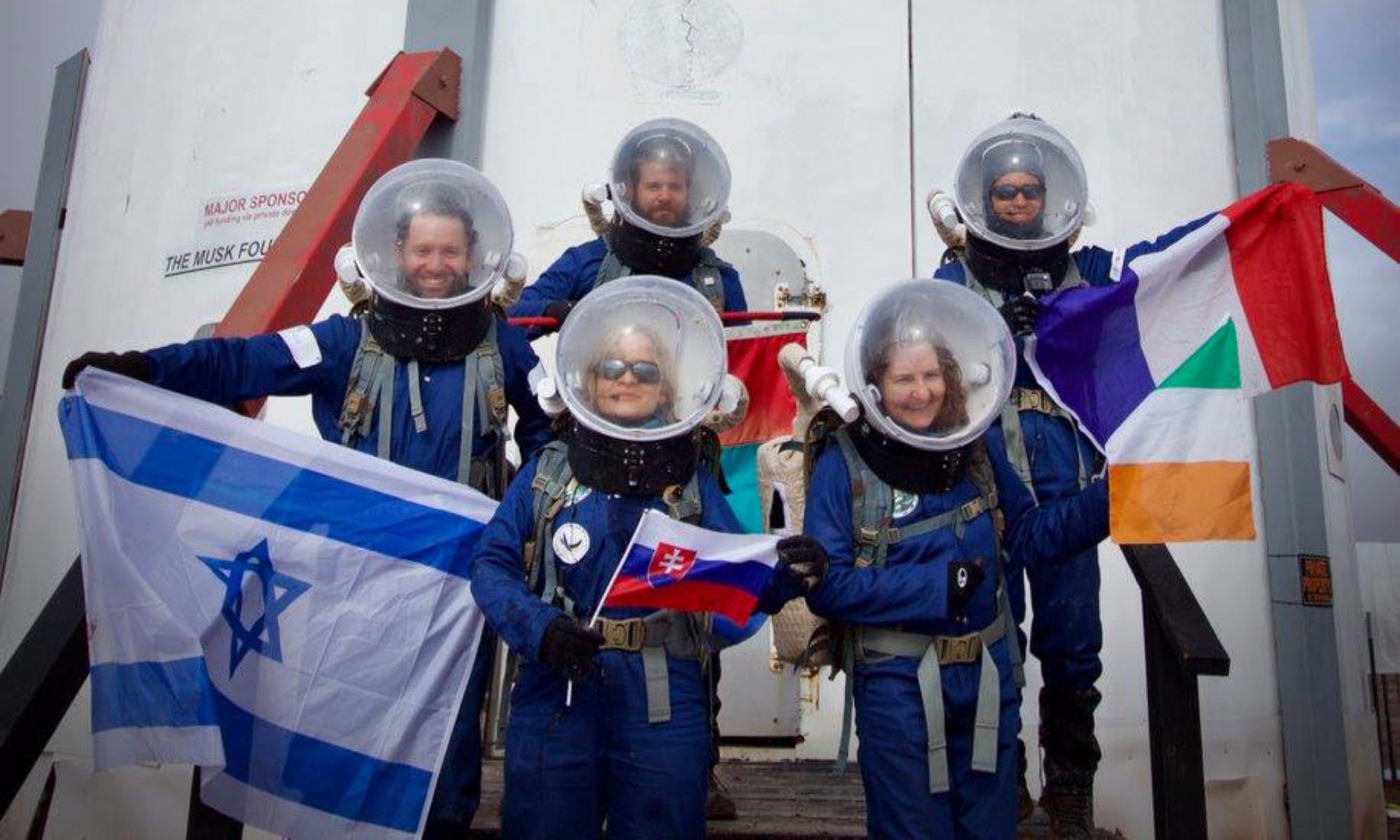
A diverse Hispanic crew, hailing from various countries across Latin America including Spain, embarks on a mission to the Mars Desert Research Station (MDRS), a terrestrial analogue for Mars exploration. This mission is of paramount importance, as it not only underscores the universality of space exploration but also represents a significant step towards equitable participation in human spaceflight. By involving the Hispanic community in such missions, we foster inclusivity and expand the talent pool, drawing on the unique perspectives and expertise that diverse individuals bring to the table. Furthermore, it serves as an inspiration to underrepresented groups, encouraging their engagement in STEM fields and space exploration, ultimately enhancing innovation and the long-term sustainability of our journey to the stars.
Below, we present the projects that the crew members will be working on:
Project 1:
The continuity of the power generation system in a Martian station is of critical importance for crew survival. This means that all single point failure parts within this system must go through preventive maintenance. This strategy seeks to detect and isolate possible faults before they cause unrecoverable failures. One key component in MDRS is the diesel power generator, which as most combustion engines, is subject to constant vibration loads that degrade the parts over its lifetime. These vibrations can be measured via a set of sensors, namely accelerometers and ultrasonic microphones, and their data used to construct a characteristic signature. By monitoring this signature over time we hope to be able to generate early alerts for the crew to realize that maintenance is needed and avoid power outages.
Project 2:
During the early years of Martian settlements there will likely not be a global navigation system available as the ones we have on Earth. Therefore, reliable methods of geolocation must be developed and kept as backups to ensure that crewmembers can always return safely to base. We can assume that the areas surrounding the base will be photographed and mapped by satellites before settlement. We propose a solution to the case where a crew is lost far enough from the station such that a drone’s range/autonomy is not sufficient to find the way back. This proposal consists of using the drone to capture an image from above of where the crew is located, and then matching the picture to the satellite image database to pinpoint the location and relative orientation towards the station.
Project 3:
The research project carried out at the Mars Desert Research Station (MDRS) of October 29 to November 11, by Crew 285, focuses on development and implementation of a safety and rescue protocol during research outings extravehicular (EVA) under simulated Mars conditions.
The main objective of this project is to guarantee the safety of the crew members, establishing clear and effective procedures for cases of loss of communication between the members who are abroad and those at the base.
A drone will be used for search and rescue, along with specific signs of communication (indications), ensuring that all crew members are properly trained and prepared to face emergency situations in an environment analogous to Mars.
It is important to use clear and easy to understand visual and auditory methods.
Sequence of Movements for each signal:
Rescue Request Signal:
The crew member in distress activates a rescue request signal, a flash of light or a specific sound signal.
– Sequence: The drone makes a circular or elliptical pattern in the air to indicate that it has received the rescue request signal.
– Meaning: This circular or elliptical pattern would indicate to the crew member in distress that the drone has received the request and is preparing for the rescue.
Position Signal:
The drone marks the GPS coordinates of the base or the crew member in distress to know her exact location. On the drone operator screen.
– Sequence: The drone performs an up and down movement pattern 3 times.
– Meaning: This would indicate to the crew member her exact location and facilitates his identification on the ground.
Direction Sign:
The drone uses patterns to indicate the direction in which the distressed crew member should move to be safely picked up.
– Sequence: The drone makes a starting movement, zigagagar and in a straight line towards the direction in which the crew member in distress must move to be picked up.
– Meaning: These movements would clearly indicate to the crew member the direction in which he should move to meet the drone and be rescued safely.
Project 4:
A drone project for prior observation and research (image collection) of a Martian area, and to prevent incidents in the EVA (Extravehicular Activity) of the Crew 285.
Project to ensure the safety and success of the EVAs by providing valuable information about the exploration area (images and videos).
The objectives of observation and investigation, such as identifying places of interest, evaluating security and ground conditions, or search for key resources.
To observe ground conditions, or search for key resources: we must use satellite images to collect data from Martian areas and then collect precise coordinates for drone use.
By combining satellite information with data collected by the drone, we will obtain a more complete and detailed view of the region of interest.
Capturing these images could reveal crucial information about the presence of water, organic compounds or other essential elements.
Project 5
For several years, experiences and results from various Mars analog missions conducted have been documented through various written records such as summaries and journalistic reports. This current study aims to undertake an exercise that enables the creation of categories for the qualitative analysis of sociocultural dynamics within these settings, with the goal of establishing recommendations for future space travel processes. In this regard, the proposed interpretive categories are intended to serve as a methodological tool for identifying, based on patterns and unique aspects within the texts, variations in the social dynamics of the crew. This, in turn, allows for the discovery of factors that may either enhance or hinder social behaviors that can positively or negatively impact the success of a space mission.
Simultaneously, the study seeks to develop a data extraction methodology for the sociological and anthropological analysis of experiences in analog simulations. By consolidating these social analysis categories, the methodology can be applied in similar real-world space environments to gather relevant information regarding human interpersonal aspects in outer space.
Project 6
Scientific Background
The colonization of Mars implies to a great extent the use of Martian resources. The great cost of sending a kilogram of payload to the red planet makes us see the great utility of using Martian soil to produce materials that can be useful for various activities. In particular, I consider the construction and obtaining of fuels and other products. At the 2016 IAC held in Guadalajara, Elon Musk announced his interplanetary transport system, in which he proposed the idea of obtaining fuel directly from the Martian environment and thus recovering enough to return to Earth. This technology, in diapers still, implies not only chemical processes that must be carried out in situ, but also the use and design of technology and tools that astronauts will have to manipulate.
The challenge
The challenge is to find the raw materials in the Martian environment, verify that the product obtained is the desired one and produce it in the required quantities.
Also, it is necessary to achieve the optimal design for the tools that will be used by astronauts for these purposes.
Proposed Solution
The initial phase of the project involves creating an observational characterization of various types of soils to identify their solid properties relevant to construction material production. Once this data is collected, it will undergo analysis, and subsequently, the production tools will be put into operation.
Project 7
PROPOSAL FOR SCIENTIFIC RESEARCH ACTIVITIES
Luis Diaz (Peru) – Astronomer & Executive Officer – Crew 285
Mars Desert Research Station, Utah, USA
SCIENTIFIC BACKGROUND:
Traditionally, false color techniques in deep space photography have relied on expensive specialized filters to capture the wavelengths of hydrogen-alpha, oxygen-III, and sulfur-II. These three elements are notably abundant, especially in nebulae, in space, making them crucial for monochromatic camera-based imaging. However, alternative methods have emerged for achieving similar results with single-shot color cameras, using narrowband dual-channel filters to extract hydrogen-alpha and oxygen-III signals.
THE CHALLENGE:
The challenge is to develop a false colorization method that can replicate the results achieved with expensive narrowband filters using a monochromatic camera, but this time exclusively utilizing standard LRGB filters. Unlike the traditional approach, this method does not involve the use of filters designed to restrict light pollution. Consequently, it is only applicable in areas with low Bortle scale ratings or requires extensive post-processing to mitigate light pollution contamination.
PROPOSED SOLUTION:
The proposed solution involves the exploration of mathematical operations applied to each color channel in an attempt to mimic the results traditionally obtained with specialized filters. The primary goal is to replicate iconic palettes like the Hubble palette using only LRGB filters with a monochromatic
camera. The process will involve careful mathematical adjustments to each color channel to create a false color image that captures the essence of the hydrogen-alpha, oxygen-III, and sulfur-II signals without the need for narrowband filters. Special attention will be given to the processing techniques required to mitigate light pollution when working in areas with higher levels of light contamination. This approach aims to provide an economical and accessible way for astrophotographers to create stunning deep space images without the need for costly specialized filters.
The following targets have been simulated in Stellarium with the MDRS location and nighttime date and time ranges during my rotation to confirm that there will be a wide window of time to capture them; Likewise, it has been validated that the size of each objective can fit perfectly into the focal ratio of the telescope and the size of the camera sensor:
Main objectives to test the method:
– Veil Nebula
– Orion Nebula
– Heart Nebula
– Horsehead Nebula.
– Rosette Nebula
Additional Objectives:
– Helix Nebula
– Crescent nebula.
– Pleiades
Targets to be processed with normal LRGB signal:
– Andromeda
– Star clusters
– Others
INSTITUTIONAL AFFILIATION:
Astronomical Association of Trujillo (ATA)
Astronomy Club of the National University of Trujillo