EVA Report – February 3th


Crew 274 EVA Report 03-02-2023

EVA # 5

Author: Sarah E. Guthrie, Commander

Purpose of EVA: Logistics Cache Deployment

Start time: 10:00am

End time: 11:30am

Narrative: EVA #5 purpose was to deploy the logistics cache in a specific location which will be retrieved in EVA #7.

Destination: South on Cow Dung Road, near Zubrin’s Head (see map provided).

Coordinates (use UTM WGS 84): N4248400, E519300

Participants: Nicholas Pender (HSO), Tony DiBernardo (Journalist), Noah Loy (Heliophysics), and Salina Pena (Astronomer)

Road(s) and routes per MDRS Map: EVA #5’s (map provided) purpose is to drive the cache and establish the power system at the way-point for EVA #7.

Mode of travel: Rovers Curiosity/Spirit *NOTE* Original Request was for Curiosity and Percy, the crew accidentally took the wrong rover.

[eva]

EVA Report – January 31th


Crew 274 EVA Report 31-01-2023

EVA # 3

Author: Sarah E. Guthrie, Commander

Purpose of EVA: To measure speed and distance of a 30 minute walking EVA as part of a logistics research study (PI: Pender)

Start time: 10:00am

End time: 11:30am

Narrative: EVA 3 departed the habitat at 10:00am for Kissing Camel Ridge as part of an research project for logistic caches. The crew traversed the surface in the direction of Kissing Camel Ridge for 30 mins to measure distance and speed. Once crew reached the base they took a 10 minutes break before returning to the habitat. The crew returned to the habitat at 11:20am. They then walked the MDRS campus and took a visual inspection before ingressing at 11:25am.

Destination: Kissing Camel Ridge

Coordinates (use UTM WGS 84): N4249700, E518700

Participants: EVA Lead – Nick Pender (HSO), Lex Lojek (Engineer), Tyler Hines (GHO), and Tony DiBernardo (Journalist)

Road(s) and routes per MDRS Map: Kissing Camel Ridge (see GPS map provided)

Mode of travel: Walking only

EVA Report – January 30th


Crew 274 EVA Report 30-01-2023

EVA # 2

Author: Sarah E. Guthrie, Commander

Purpose of EVA: Training

Start time: 1:00pm

End time: 1:55pm

Narrative: EVA 2 completed MDRS required training at Marble Ritual for approximately 24 mins.

Destination: Marble Ritual

Coordinates (use UTM WGS 84): N4240700, E518750

Participants: Lex Lojek (Engineer), Tyler Hines (GHO), Salina Pena (Astronomer), Noah Loy (Heliophysics)

Road(s) and routes per MDRS Map: Cow Dung Road to Marble Ritual

Mode of travel: Rovers (Curiosity, Opportunity)

EVA Report – January 30th


Crew 274 EVA Report 30-01-2023

EVA # 1

Author: Sarah E. Guthrie, Commander

Purpose of EVA: Training

Start time: 10:25am

End time: 10:59am

Narrative: EVA 1 completed MDRS required training at Marble Ritual for approximately 24 mins.

Destination: Marble Ritual

Coordinates (use UTM WGS 84): N4240700, E518750

Participants: Sarah E. Guthrie (Commander), Nick Pender (HSO), Bill O’Hara (Hab Specialist), Tony DiBernardo (Journalist)

Road(s) and routes per MDRS Map: Cow Dung Road to Marble Ritua

Mode of travel: Rovers (Perseverance, Spirit)

EVA Report – January 13th


Crew 272 EVA Report 13-01-2023

EVA # 10

Author: Arly Black

Purpose of EVA: Simple simulation of search and rescue of an incapacitated astronaut. In this case, the astronaut was the Boiler Transmission Station (BTS) located at N519600, E4251500.

Start time: 9:00 AM

End time: 10:50 AM

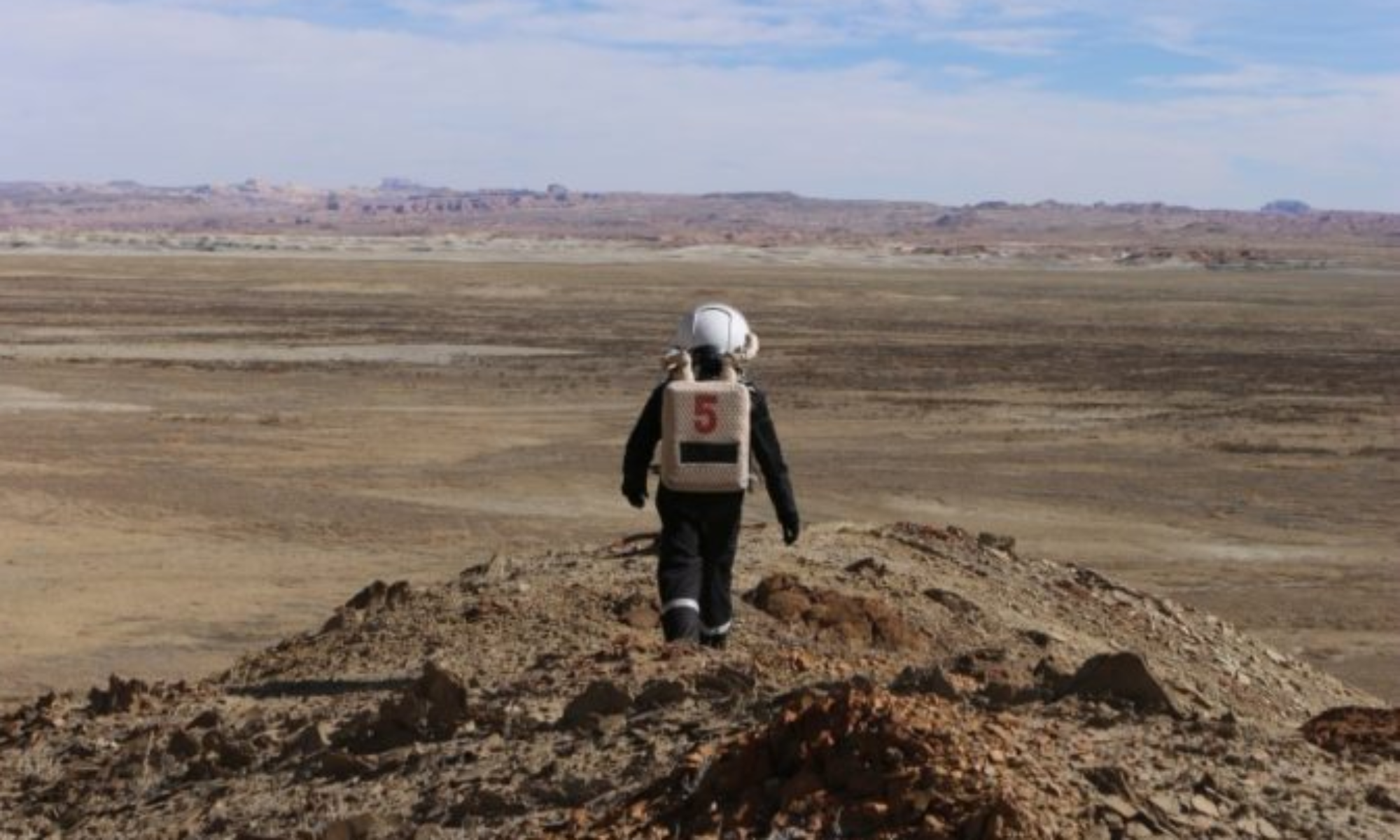
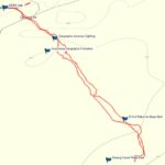
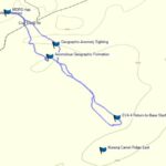
Narrative: Today’s EVA started off a lot earlier than the rest of them have this mission. This was the last EVA of our rotation (noooo!) and we were eager to get started and save our lost astronaut/Kshitij’s baby (and also to get back early to write our many final mission reports). After wiping the sleep from our eyes, a quick stretch, and a rushed breakfast, the EVA crew jumped into our suits, which by now we need no assistance to put on. Five minutes of space jokes (Why aren’t astronauts hungry when they get to space? Because they had a big launch!) made the airlock prebreathing pass by quickly. It was a chilly morning and when we got to our rovers, there was frost on our seats. Some of us wish we had noticed that before sitting down… Arly and Mason led the way to our destination in Spirit (and with spirit!) with Kenny and Megan following in Opportunity. We drove to the Gateway to Candor and parked, using the mound on the right side of the road to help us navigate on-foot to our destination, based on experience from the last EVA to the self-named Boiler Ledge. When we reached the top of the hill, Mason flew our search and rescue drone to see if our lost astronaut BTS (transmitter + box, not the K-Pop band) was still there. He was unable to see anything and lost connection at some point, so we continued walking towards the ledge. At a closer point about 300 ft from the ledge, Mason again attempted to spot the astronaut with the drone. He was unable to see it on the live feed but was later able to view it clearly during post-processing. Hopefully, in a real-life situation, the astronaut doesn’t mind waiting a few extra hours for rescue… Meanwhile, the other three EVA members walked towards the ledge and found the transmitter lying exactly where we expected it to be, which was surprising given the high winds and rain from a Martian storm we experienced a few days ago. Unfortunately, we found the box halfway down the cliff facing Compass Rock. While we could have scrambled down the cliff to rescue it, the crew made an executive decision to put our safety first and to leave it behind. Sometimes we astronauts must follow the pirate’s code. After all, dead men tell no tales. With that, we gathered up the transmitter booty, took some epic pictures and drone videos, left the box to its fate in Davy Jones’ locker, and sailed back to the Hab.

As a fun addition to our mission, Space Kidz India sent us some great questions from K-12 students about life on Mars and we had a great time answering a few of them while on this EVA. We discussed topics including the Martian atmosphere and why spacesuits are necessary, as well as what a Mars analog mission is and why it is important (and fun!).

And with that, we concluded another successful EVA and ended Crew 272’s final in-sim expedition. Ever. New friends, incredible views, and an experience we’ll never forget. Thank you MDRS.

“I may not have gone where I intended to go, but I think I have ended up where I intended to be” – Douglas Adams.

Destination: Ledge overlooking Compass Rock (named Boiler Ledge by Crew 272)

Coordinates (use UTM WGS 84): N519600, E4251500

Participants: Megan Rush (HSO), Mason Kuhn (Crew Engineer), Arly Black (XO/Crew Scientist), Kenny Pritchard (Crew Journalist)

Road(s) and routes per MDRS Map: Drove north along Cow Dung Road until Gateway to Candor and parked the rovers. From Gateway to Candor, walked on foot to N519600, E4251500 and retrieved the transmitter. Returned on foot to the parked rovers and drove back to the Hab along Cow Dung Road.

Mode of travel: Walking and driving

EVA Report – November 25th


Crew 272 EVA Report 12-01-2023

EVA # 9

Author: Arly Black

Purpose of EVA: 1) Geologic EVA to Cowboy Corner to investigate an inverted paleochannel identified by Clarke and Stoker (2011). 2) Test of 3D printed geologic tools.

Start time: 11:00 PM

End time: 2:15 PM

Narrative: It being Sol 11, Crew 272 is now old hat at getting ready and suited up for EVAs, and we were ready and out the door in no time. Megan and Adriana led the way in Curie, while Arly and Kenny followed in Oppy. It was a gorgeous, sunny day. The crew drove north along Cow Dung Road towards Cowboy Corner, parked the rovers, and walked west. We made our way to the inverted paleochannel — or giant mound for us non-geological folks — Adriana had identified for investigation. Our first task was to test the 3D printed rock hammers Megan created back at the Hab throughout our mission. One was a lovely pale green and made of PLA material, while the other was smaller, bright purple, and made of PETG material. Both contained 20% infill, which is a characteristic that dictates material strength, structure, and weight. Both hammers proved useful for digging and prying soft sediment, but neither were very beneficial for hammering hard rock as they lacked a certain heaviness in the hammer head. Adriana preferred the smaller hammer as it felt stronger, which aligns with the material strength specs of PETG. Adriana also enjoyed how light the hammers felt in her tool belt, relative to her bulky metal hammer.

We proceeded to walk around the large mound, exploring the many boulders and features of the area. Adriana dictated lithologic descriptions to Arly and collected hand samples that contained sedimentary structures. She documented more paleo flow indicators and compared it with findings from Kissing Camel Ridge. She noted that it looks to have a very similar depositional environment to KCR in terms of the sediment and paleo flow indicators. This makes her believe that they are a conjoined fluvial system – in other words, they are part of one system that existed at the same time. Adriana also thinks she found coal in both locations which further explains the depositional environment. “The story is slowly coming together!”, she announced excitedly, as the rest of the crew nodded, pretending to understand. And with that, Professor Brown’s Mars geology course came to an end. I think I speak for the rest of the crew when I say Adriana is going to make an incredible Professor one day.

Having accomplished all we came to do, we headed back to the Hab 15 minutes early. No alien sightings today. It’s really starting to feel like Mars out there.

Destination: Cowboy Corner

Coordinates (use UTM WGS 84): N518800, E4253000

Participants: Megan Rush (HSO), Adriana Brown (Crew Geologist), Arly Black (XO/Crew Scientist), Kenny Pritchard (Crew Journalist)

Road(s) and routes per MDRS Map: Drove north along Cow Dung Road until Cowboy Corner. Parked the rovers and walked west along the inverted paleochannel (0.5 km west of Cow Dung Road).

Mode of travel: Walking and driving

EVA Report – January 11th


Crew 272 EVA Report 11-01-2023

EVA # 8

Author: Arly Black

Purpose of EVA: Exploratory EVA to Hab Ridge, initial scouting of geologic setting.

Start time: 2:00 PM

End time: 4:15 PM

Narrative: Due to unpredictability in the weather and rover charging mishaps, today’s EVA reverted to Plan B: hike to Hab Ridge and explore the area without any preconceptions of what to expect. This time, no rovers were harmed in the making of the EVA. The crew walked from the Hab along road 1103 towards North Ridge. They took a left and walked towards Hab Ridge Road. Along the way, the curious traveler stopped to collect samples and examine their surroundings. They then continued on towards Hab Ridge Road, which runs north and south and lies to the west of the Hab, where they found a ridiculous amount of “devil’s toenails” (a genus of extinct oysters, also known as Gryphaea). They walked until they reached the repeater (it’s still standing!) and were able to see our glorious Hab off in the distance. This was the goal of the mission and therefore mission success was achieved! The crew did note that this EVA required more skillful map reading than any other EVA so far.

As this was an exploratory mission, the crew used the experiences from this EVA to brainstorm ideas for future EVAs (but only two days of EVAs left ☹!!!). Adriana examined the geological environment and tried to see how well defined the strata were in that location and what kinds of fossils were present. She was not expecting to see that many toenails which is indicative of an ancient marine environment in that area (or many giants with nail clippers). She is interested in investigating what they have been preserved in. The strata are not well defined along Hab Ridge Road, and it is difficult to see the contact between formations.

On their way back to the Hab, Adriana did some more digging, as one does, and was excited to find even MORE toenails – who wouldn’t be?! Many photos were taken to document the area and they trundled on back to the Hab along the same route. Well done explorers! But leave those toe clippings off the kitchen table, would ya?

Destination: Hab Ridge

Coordinates (use UTM WGS 84): N517800, E4251500

Participants: Adriana Brown (Crew Geologist), Kshitij Mall (Crew Commander), Madelyn Whitaker (GreenHab Officer), Megan Rush (HSO Officer)

Road(s) and routes per MDRS Map: Walked on foot up Road 1103 until Hab Ridge, then returned on foot by Road 1103 to the Hab.

Mode of travel: Walking

EVA Report – January 10th


Crew 272 EVA Report 10-01-2023

EVA # 7

Author: Arly Black

Purpose of EVA: Simple simulation of search and rescue of a lost/injured astronaut at Kissing Camel Ridge. Drone versus human performance is evaluated in the context of efficiency of finding the astronaut.

Start time: 10:00 AM

End time: 1:00 PM

Narrative: The EVA began extra on-time today as Arly and Madelyn were over-eager to go kick some drone butt. The crew hustled into the airlock and about 3 minutes in realized they had no maps… After grabbing the maps and starting the airlock countdown again they emerged into the sunlight. Madelyn and Arly hopped into Spirit with Madelyn driving, while Mason and Kshitij rode in Perseverance with Kshitij driving and leading. They drove to Kissing Camel Ridge where, once again, no camels were observed, kissing or otherwise. Kshitij went to hide the lost astronaut (i.e. a cardboard box) on the east side of the ridge, while the other three turned their backs and played with colourful rocks like preschoolers in a sandbox. Kshitij maintained line of sight with the rest of the EVA crew the entire time. The east side of the ridge is flat with several large boulders and one hilly mound, so it is ideal for maintaining LOS while providing numerous hiding places. Kshitij said “go” and the competitors were off! The drone sped on ahead, while Arly and Madelyn split up to cover more ground. The human strategy turned out to be a roaring success as Madelyn let out an “AAAHHHH” and the lost astronaut was discovered behind a large boulder on the north side. Mason complained of drone connectivity issues, but we don’t tolerate excuses when it comes to saving cardboard lives.

The next test saw Kshitij hiding the lost astronaut on the west ridge. This time, Madelyn and Arly stuck together in their search given the hilliness of the landscape. The drone again experienced connectivity issues, prompting it to consistently return to its owner. At one point the drone was hovering almost directly above the hill upon which the astronaut was hiding, but the poor connection left Mason unable to see the poor soul he was there to rescue. Given Kshitij’s slight bias towards the drone, he announced prematurely that the drone had won, but the wily female searchers seized the moment and ran to retrieve the astronaut from its lonely mountain peak. Once again, human resilience and ingenuity wins the day. Although, if we’re being honest, the drone would have won if not for the connectivity mishaps (hope you’re okay with a pity win, Mason). After two successful rescue attempts (from the lost astronaut’s point of view, if not the drone’s), the EVA crew packed up and journeyed home with pockets full of petrified wood. What a beautiful day for a rescue!

Destination: Kissing Camel Ridge

Coordinates (use UTM WGS 84): N518400, E4249500

Participants: Kshitij Mall (Crew Commander), Mason Kuhn (Crew Engineer), Madelyn Whitaker (GreenHab Officer), Arly Black (XO/Crew Scientist)

Road(s) and routes per MDRS Map: Drove south on Cow Dung Road until Kissing Camel Ridge. Walked on foot along ridge to the east and west relative to Cow Dung Road. Returned to rovers on foot and drove back to the Hab via Cow Dung Road.

Mode of travel: Driving and walking

EVA Report – January 9th


Crew 272 EVA Report 09-01-2023

EVA # 6

Author: Arly Black

Purpose of EVA: 1) First geology EVA to Kissing Camel Ridge. Specific focus on evidence of KCR as an inverted paleochannel as proposed by Clarke and Stoker (2011). 2) Geologist vs non-Geologist field performance evaluation. 3) Drone scouting of surrounding area for feasible search and rescue simulation location of future EVA.

Start time: 11:00 AM

End time: 2:00 PM

Narrative: Upon placing the fancy, new, plush headsets on their heads, the EVA crew knew their days of comms issues were over. It was love at first “copy”. With the previous headsets banished to the town of non-nominal toys, EVA prep went off without a hitch, and all explorers were suited up, thrust into the airlock, and exposed to awful puns with time to spare. The crew exited the airlock and danced their way to Opportunity and Curiosity (don’t think we didn’t see those moves Kenny and Kshitij). They drove south along Cow Dung Road, parked where the road intersects with Kissing Camel Ridge, and continued on foot 100 m south of the west ridge. Kshitij and Mason proceeded to use the drone to scout out potential locations in which to perform their search and rescue research operations. They found that the southern part of the ridge is simply perfect for their planned activity due to clear lines of sight and several good hiding places for a lost astronaut. The drone range reached 2800 ft, more than enough to cover the search grid of interest. Mason then took videos of crew members enjoying their time out in the field.

Simultaneously, Adriana and Kenny went further up the ridge, but within light-of-sight, searching for more paleoflow indicators (Adriana is worried about overusing those words, but I don’t think I’ll ever get sick of them). She took dip measurements, documented around 12 different sites of paleoflow indicators, and wrote some lithologic descriptions. She collected samples with sedimentary structures in them and excitingly, she believes she has found coal seams (geologists rejoice!). Along with minor frolicking and rock-hugging, Kenny documented crew activities and participated in further geologist vs non-geologist performance tests. Besides formations allegedly shaped like large, amorous, humped mammals, the ridge is also home to a staggering amount of petrified wood, which the crew gathered in droves! After taking a final group shot with the drone, the team packed up their supplies and their hard-earned booty and made it back to the Hab a half hour early as they had achieved all their objectives. Ultimately, this was a very successful EVA and the remaining crew back at the Hab can’t wait to get out there to collect some colourful terrified tree bark of their own!

Destination: Kissing Camel Ridge

Coordinates (use UTM WGS 84): N518400, E4249500

Participants: Kshitij Mall (Crew Commander), Mason Kuhn (Crew Engineer), Kenny Pritchard (Crew Journalist), Adriana Brown (Crew Geologist)

Road(s) and routes per MDRS Map: Drove south on Cow Dung Road until Kissing Camel Ridge. Walked on foot along ridge to the east and west relative to Cow Dung Road. Returned to rovers on foot and drove back to the Hab via Cow Dung Road.

Mode of travel: Driving and walking

EVA Report – December 29th

EVA #13

Author: Cesare Guariniello

Purpose of EVA: 1) Collecting rocks and clay samples above Hab ridge and at the foot of Skyline Rim. These samples are for analysis of properties for In-Situ Resource Utilization 2) Radio communication check.

Start time: 1230
End time: 1510

Narrative: The crew left the Hab area on foot, followed route 1103 up to Hab Ridge. Communication with the habitat was tested on top of the ridge with excellent results. During the walk, extensive videographic and photographic footage was collected. The crew sampled the soil along the way and walked about 4km, up to the bottom of Skyline Rim. Climbing in the middle of two alluvial fans, the crew found loose samples assumed to come from the layers above. In particular, one fan had boulders made of relatively large-grain sandstone. A secondary fan was strewn with large rectangular slabs of red shale. The whole EVA crew helped collect samples. Another radio communication check showed that the repeater installed on Hab Ridge allows for direct communication with the habitat from Skyline Rim. After a few minutes to rest and enjoy the beauty of the extensive view from Skyline Rim, the crew headed back to the hab.

Destination: Skyline Rim

Coordinates: 515430, 4251442

EVA Participants: Käosaar, Eifert, Iakymov, Guariniello

Road(s) and routes per MDRS Map: Walked from the Hab to Hab Ridge along 1103 (Sagan Hwy), then followed 1103 to the foot of Skyline Rim

Mode of travel: Walking

Copyright © The Mars Society. All rights reserved. | Main Site