EVA Report – April 20th

Crew 280 EVA Report 20-04-2023

EVA #4

Author: Laia Ribas (GreenHab Officer) and Carla Conejo (Executive Officer & Biologist)

Purpose of EVA: This EVA allowed us to perform different tasks:
We checked the communications between the Midland radios that we brought for a larger distance between the EVA crew and the base. We also continued to familiarize ourselves with the spacesuits and communication and safety protocols during EVAs and tried a new location to drive with the rovers.
We evaluated the feasibility of navigation strategies developed by Ariadna Farrés (Scientist & HSO).
We collected some soil and rock samples to search for organic molecules for Laia Ribas’ (GreenHab Officer) CatMart project. This procedure was recorded and documented as it was an outreach activity.
For the first time, our drone was flown by Carla Conejo (XO & Biologist; TRUST Certified) and Mariona Badenas (Commander & Astronomer).

Start time: 14:09 PM

End time: 16:15 PM

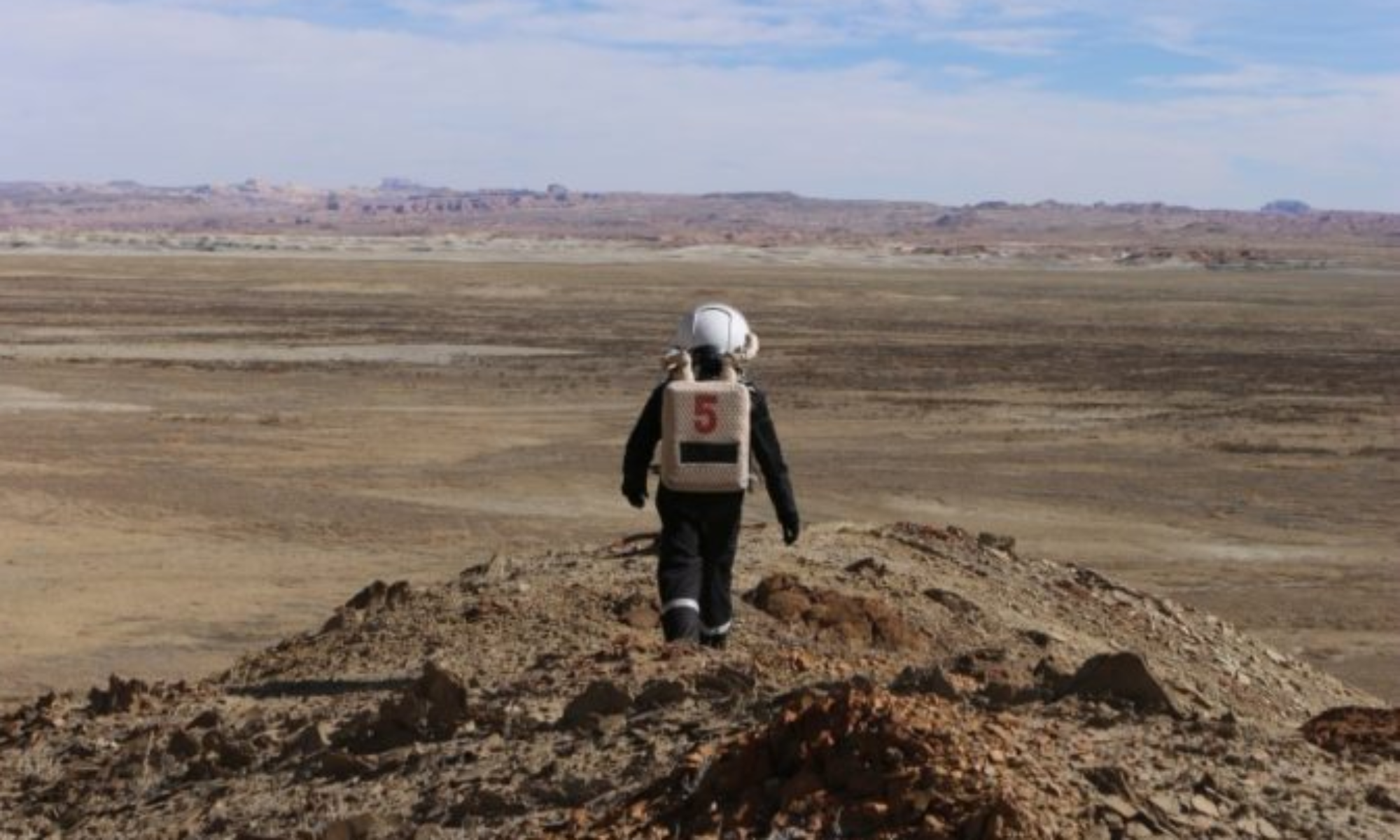
Narrative: After performing 5 minutes of depressurization in the front airlock, we drove Curiosity and Perseverance rovers to Cowboy Corner to perform four main tasks: 1) test our Midland radios; 2) develop navigation strategies away from the station; 3) collect samples for the CatMart project; 4) and maneuver our small drone.

After arriving at Galileo Road, we lost communication with the base and were only able to communicate with the Hab team with our own Midland radios. With the latter, the communication between the EVA and base teams worked well during the whole time.

When reaching our destination, we parked the rovers and walked west to collect soil and rock samples for the CatMart project and test the drone. Laia Ribas (Green Hab officer), Principal investigator of the CatMart project, together with Ariadna Farres (HSO) walked into a spot located in the north of the esplanade of Cowboy Road to obtain samples for the project and get some data for the navigation project lead by Ariadana Farres. The other crew members, Mariona Badenas (Commander & Astronomer) and Carla Conejo (Executive Officer & Biologist) performed maneuvers to perform drone tests. The tests were very successful, although there was some wind. We also took beautiful pictures with Hypatia and Earth flags.

After 1 hour, we walked back to the rovers, and we drove back to the MDRS while first stopping at Pooh’s Corner. In this spot, the communication with the base was recovered. We walked to the west to continue maneuvering the drone for 15 min to finalize our EVA driving safely to the station. Before entering the Hab, we followed the 5-minutes pressurization protocol.

Destination: Cowboy Corner

Coordinates (use UTM WSG 84): 519000 E, 4253000 N

EVA participants: 4: Laia Ribas (GreenHab Officer) (EVA Leader), Mariona Badenas (Commander & Astronomer), Ariadna Farrés (HSO), Carla Conejo (XO & Biologist)

Road(s) and routes per MDRS Map: Drive on Cow Dung Road 0110

Mode of travel: Drive on Cow Dung Road 0110 to Cowboy Corner then walk around no farther than 400 meters for sampling

EVA Report – April 18th

Crew 280 EVA Report 18-04-2023

EVA #3

Author: Mariona Badenas (Crew Commander and Astronomer) and Carla Conejo (Executive Officer & Biologist)

Purpose of EVA: The main goal of the EVA was to collect iron oxide samples for Neus Sebaté’s (Mission Specialist) research project, which consists of building Martian batteries with iron materials. During this EVA, Carla Conejo (Executive Officer & Biologist) supported Neus in the sampling process, Mariona Badenas (Commander) was in charge of the navigation, and Núria Jar (Journalist) documented the EVA for her podcast. The EVA group was accompanied by two media teams (documentary and Catalan TV press teams).

Start time: 11:20AM

End time: 12:47PM

Narrative: The EVA was planned for 11AM, but it finally started at 11:20AM. It took 30 minutes for the crew to get ready, and during this time, both the media and the documentary team recorded the preparation of the EVA. After performing 5 minutes of depressurization in the front airlock, we drove Curiosity and Spirit to Marble Ritual to gather iron-rich rock samples for Neus Sabaté (Mission Specialist). With these samples, Neus will try to build batteries with Martian-like materials.

After a smooth but windy drive to our destination, we parked the rovers and walked east of Marble Ritual, where we located many black and reddish rocks with iron oxide materials. Mariona Badenas (Commander & Astronomer) and Carla Conejo (Executive Officer & Biologist) assisted Neus with the rock sampling process, while Núria Jar (Journalist) reported the whole process with beautiful pictures (see “Pictures of the Day”).

During this time, the broadcasting team filmed the crew, although all EVA teams made the effort to disregard their presence to respect the simulation. We completed the scientific goals of the EVA at 12:15PM, after walking and sampling for 1 hour at about 400m from where we parked the rovers. After that moment, we communicated our intended route back to the rovers to the media team through a radio that we provided them, and they followed us with a drone.

We then drove back and returned to the Hab, where we followed the 5-minutes pressurization protocol. The first media team abandoned the area soon after, while the documentary team entered the base a few minutes after the EVA team returned to the base. Although we had a windy expedition, we experienced no problems during this EVA.

Destination: Originally Cowboy Corner, but Marble Ritual.

Coordinates (use UTM WSG 84): 519000 E, 4250500 N

EVA participants: 4: Mariona Badenas (Commander) (EVA Leader), Carla Conejo (Executive officer & Biologist), Neus Sabaté (Engineer), Núria Jar (Journalist).

Road(s) and routes per MDRS Map: Cow Dung Road 0110.

Mode of travel: Drive on Cow Dung Road 0110 to Cowboy Corner then walking around no farther than 400 meters for sampling.

EVA Report – April 17th\

Crew 280 EVA Report 17-04-2023

EVA #1

Author: Mariona Badenas (Commander and Crew Astronomer) and Carla Conejo (Executive Officer)

Purpose of EVA: The goal of the first EVA was to perform a training for the first half of the crew, where we practiced communication between the crew members participating in this EVA and the Hab. The location for exploration was the Marble Ritual.

Start time: 3:20pm

End time: 4:54pm

Narrative: The EVA was planned for 2pm, but it started about 1h:20 min later. The reason for the delay was that the crew was waiting for three members to return from the hospital, which pushed our EVA training session to the early afternoon. The goal of the EVA was to test the rovers, practice the protocols regarding the spacesuits, and get used to the radio communication between the EVA and Hab team.

It took about 40 min for the EVA team to get ready to exit the Hab. For this EVA we used Curiosity and Perseverance rovers and we drove to Marble Ritual through Cow Dung Road 0110. After reaching our destination, we parked the rovers by the road and walked 300m around a hill to get used to moving around with the suits. During this time, all communications went very smoothly and the team took some pictures that are being attached in the journalist report. After some minutes walking around the area, we were contacted by the base to start our way back to the rovers.

Just before starting our drive back to the MDRS, Ariadna Farrés (communication leader in the base) could not establish contact with Mariona Badenas (communication leader in EVA) through channel 1; Mariona was able to hear Ariadna though. Carla Conejo switched to channel 1 –although not need for EVA performed in locations close to the MDRS– to respond to the base requirement to start our way back. In 15 min we reached the station and parked the rovers. Laia Ribas also experienced communication issues while informing about the rover’s battery level and driving hours. We then returned to the base and started with the decompression in the airlock and safe return of the astronauts to the base.

Destination: Marble Ritual
Coordinates (use UTM WGS 84): 519000 E, 4250500 N

Participants: Mariona Badenas (Commander) (EVA Leader), Carla Conejo (Executive officer & Biologist), Neus Sabaté (Engineer), Núria Jar (Journalist).

Road(s) and routes per MDRS Map: Cow Dung Road 0110.

Mode of travel: Drive on Cow Dung Road. Walk around Marble Ritual no further than 300 m from the rovers.

EVA: #2

Author: Ariadna Farrés, Crew Scientist and Health & Safety Officer

Purpose of EVA: The goal of this second EVA was to perform a training for the crew, where we practiced communication between the crew members in this EVA and the Hab. The location for exploration was the Marble Ritual.

Start time: 5:10pm

End time: 6:03pm

Narrative: The EVA started one hour later than requested as the first EVA of the day had already been delayed. The goal of the EVA was to get comfortable with the spacesuits and practice the different EVA protocols, the communication between EVA and the Hab and get familiar with the environment. This was the second time the crew was performing the PRE EVA protocol, and things went smoother than during the first EVA of the day. It took the crew 30 min to get ready to get out of the Hab.

The crew used Opportunity and Spirit for this second EVA. The first part of the EVA consisted of getting to Marble Ritual with the rovers. Once there the objective was to walk around the Marble ritual area to discover the place and get used to walking around with the spacesuits and radio communications. The crew also wanted to test the communications with the Hab using the Hypatia I personal radio set. Cesca, as the mission specialist was the one responsible to test the radio set and was caring with her two radio sets, radio number 7 from the MDRS base and the Hypatia I radio. When the crew arrived at Marble Ritual (and out of the rovers), we tested the communications with the base using the Hypatia I radios. The communications went well after adjusting the radio frequency. Once the Hypatia I radio set was tested successfully the crew decided to explore the surroundings of Marbel Ritual. This walk consisted of 15 min of the EVA where we walked around and got comfortable with the spacesuits. No communication problems seemed to exist with the Hab during the entire EVA.

Finally, the crew started the return to the Hab with the rovers. During the return to the Hab we decided to have Spirit lead the road followed by Opportunity. Upon arrival to the Hab we checked the hours and batteries usage of all rovers and started with the decompression in the airlock and safe return of the astronauts to the base.

Destination: Marble Ritual.

Coordinates (use UTM WSG 84): 519000 E, 4250500 N

EVA participants: 3: Ariadna Farrés (HSO) (EVA Leader), Núria Jar (Journalist), Cesca Cufí (Mission specialist).

Road(s) and routes per MDRS Map: Cow Dung Road 0110.

Mode of travel: Drive on Cow Dung Road. Walk around Marble Ritual no further than 500m from the rovers.

EVA Report – April 14th

Crew 279 EVA Report 14-04-2023

EVA: #14

Author : Augustin Tribolet, Crew GreenHab

Purpose of EVA: For the EVA, we wanted to map further away from the station. This was to help us to complete the global map of the region which will be useful for future teams. This was Augustin’s last mapping, it is interesting for him to scan a region that has a rather flat relief compared to the previous ones that were more relevant.

We also wanted to measure radioactivity in that part of the region and collect some samples of a place we haven’t been to yet for analysis. Thomas briefed Ttele on how to use the scintillator before the EVA and this was to give information on how easy of use the scintillator is for a non-physicist. This information will be useful for our sponsor BeSure to help them make better instruments in the future. In the case that on the terrain the device turned out to not be intuitive enough to use by our astronauts, they were to collect samples to be analyzed upon return by a lab in our university. Ioana was there to assist Augustin by keeping eyes on the drone and to help Ttele with her measurements and collections. She was also to be useful for timekeeping and experiment coordination.

Start time: 9:40am

End time: 12:01pm

Narrative:

The 3 crew members took the rovers and arrived at their destination at 09h40. During this EVA, Charitum Montes was mapped for photogrammetry purposes. Ttele and Ioana used the scintillator successfully. At the end of the EVA, the drone’s connection was lost, which caused the drone to automatically retreat to its landing point. The team had to return to the launching point to retrieve Ingenuity. EVA ended at 12:01.

Destination: Charitum Montes

Coordinates (use UTM WGS 84): 518500 E, 4248250 N

EVA Participants: Augustin (EVA Leader) (Green Hab Officer), Ttele (HSO), Ioana (Crew Engineer)

Road(s) and routes per MDRS Map: Cow Dung Road 0110

Mode of travel: Drive on Cow Dung Road 0110 to Zubrin’s Head then walking to Charitum Montes no further than 400m

EVA Report – April 13th

Crew 279 EVA Report 13-04-2023

EVA #12
Author: Agnès Dekeyser, Crew Executive Officer
Purpose of EVA:
The goal was to recover Agnes’ bacteria samples in North Ridge that we put in 5 days ago. She will bring them back to the Science Dome where their viability will be assessed and compared to their unexposed analog. Antoine was in support to carry the bacteria
This EVA was the last for Thomas’ experience. He had to take radioactivity measurements near the base with his detector. Thanks to a scintillator, he made punctual measurements of radioactivity (gamma emission) every 10 meters. He only had one zone left South-West from Hab (he aims for 50-100 measurements). His route was like a snake shape: (North (250m)-West (10m)-South (250m)-West (10m)-North (250m) and so on).
It was difficult to make measurements with only 1 person in support during the last EVA so he was helped by Agnes and Augustin who took note and guided him in his tracing with a GPS.
Start time: 8h14
End time: 11h59
Narrative:
The day started very early without the pancakes planned in the morning due to the difficulty the crew had in waking up. Anyway, some cereals did the trick to give energy to our martionauts going to EVA. They began their journey with the North Ridge to recover Agnès’ samples. Her bacteria samples have been placed there since Sol 5 to be exposed to Mars’ extreme condition and are now analysed in the science dome to assess their viability. They also took some time to enjoy the view one last time before going back to the rovers to begin Thomas’ experiment. Next to the rovers, our martionauts were photographed by some very curious martians.
After that, they drove back to the MDRS and transmitted the rover’s parameters to the Hab. Then, they went to the first GPS coordinates and began radioactivity measurements. Unfortunately, the scintillator was not working and they lost a bit of time to make it work. After changing the battery, it seemed to work and they were able to take all the measurements needed.
They came back in time to the Hab and both missions were a success.
Destination: North Ridge and Mars Desert Research Station (MDRS)
Coordinates (use UTM WGS 84): 518500 E, 4251750 N and 518200 E ,4251000 N
Participants: Agnès (Eva Leader)(XO), Antoine (Commander), Thomas (Scientist), Augustin (Greenhab)
Road(s) and routes per MDRS Map: Cow Dung Road 0110
Mode of travel: Drive on Cow Dung Road 0110 to North Ridge then walking on the top of North Ridge. Then driving back to MDRS and walking no further than 300 meters.

EVA #13
Author : Aglaé Sacré, Crew journalist
Purpose of EVA:
Extensive mapping of Candor Chasma was carried out during SOL 6. Upon reprocessing the images, several intriguing locations were identified for the GHO’s experiment. Notably, certain cavities were found that may offer protection against radiation for human beings. Following measurements taken from a 3D model and instruction from Augustin, the EVA crew intended to validate his model’s effectiveness by localisation accuracy for a crew who haven’t seen the 3D map and performing identical measurements on-site. Ttele and Aglaé were to be the delegates of this mission.
Gwenael, our cameraman, had to be present to take beautiful shots in Candor Chasma for our sponsors, our networks and Belgian media who had requested an idyllic location. Antoine had to be there to help Gwenael carry the equipment and install everything to be efficient and save time.

Start time: 2:24pm
End time: 5:10pm

Narrative:

After a first mapping of the area by our GHO Augustin, the goal of this EVA was following measurements taken from a 3D model and instruction from Augustin, the EVA crew intended to validate his model’s effectiveness by localisation accuracy for a crew who don’t have seen the 3D map and performing identical measurements on-site.
We were able to find one and take the necessary steps.

The objectives of the EVA were completed, and interesting cavities were found. We also took the last images needed for our report.
We advanced several tens of minutes from the Candor Chasma and then we went back to the rover to join the station.

The EVA Crew was back at the Hab at 17:10.

Destination: Candor Chasma
Coordinates (use UTM WGS 84): 521500 E ,4251000 N
Participants: Aglaé (EVA Leader) (Journalist), Ttele (HSO), Gwenael (Astronomer), Antoine (commander)
Road(s) and routes per MDRS Map: Cow Dung Road 0110 and Galileo Road 1104
Mode of travel: Drive on Cow Dung Road 0110 and Galileo Road 1104 to Compass Rock then walking to Candor Chasma.

EVA Report – April 12th

Crew 279 EVA Report 12-04-2023

EVA #10
Author : Antoine de Barquin Crew Commander
Purpose of EVA:
During the maximum activity of the sun, extreme solar events could occur that could also contribute to radiation on Mars. In particular, coronal mass ejections (which occurred during magnetic field line reconnections) could eject large amounts of energetic particles into space. Under certain conditions, the particles could reach the surface of Mars and could surprise astronauts during an extravehicular activity. The idea behind this EVA was to use the drone to see how to make use of the terrain at Tharsis Montes region to protect ourselves from those unpredictable events. In contrast with the previous EVA where precise maps were done, the idea for this EVA was to perform a fast scan of the terrain there with the constraint of time. As always, one person was needed in support to keep an eye on the drone, and it was Gwenael. Thomas was needed during that EVA to measure radioactivity levels of these hiding spots thanks to his scintillator. Antoine was needed there in support to note the GPS coordinates and the activity measured.
Start time: 8:13am
End time: 11:53 pm
Narrative:
We first drove to the cowboy corner to park the rovers. Then we started the walk in direction of Tharsis Montes while passing by the canyon. Thomas made radiation measurements in the canyon with the help of Antoine to complete his study. The measurements in the canyon did not exceed 15 counts per second, so it was only the background that we measured; no isotope found. Augustin and Gwenael worked to complete the mapping for Augustin’s program.The mapping of the area by the drone was a success. The first data exports are promising and will be processed in the coming days. The pooling of radiation and drone data is therefore less interesting for this time As we were efficient and finished a bit early, Gwenael took the opportunity to make a photo shoot to thank our sponsors at the end of the EVA.
Destination: Canyon north of Tharsis Montes.
Coordinates (use UTM WGS 84): 519000 E, 4254000 N
Participants: Antoine (EVA Leader)(Commander), Thomas ( Scientist ), Gwen ( astronomer ) , Augustin ( GHO )
Road(s) and routes per MDRS Map: Cow Dung Road 0110
Mode of travel: driving to Cowboy Corner then walking to the canyon north of Tharsis Montes.

EVA #11
Author : Ttele Hiriart, Crew Health and Safety Officer
Purpose of EVA:

During SOL 3, the Kissing Kamel Ridge W has been mapped extensively. After reprocessing the images, some interesting areas have been found for the purpose of the GHO’s experiment. We discovered some cavities that could protect humans from radiation. After making some measurements on the 3D model, Augustin needed to check the efficiency of his model by making the same measurements on the field. Ttele was there to help with measurements and GPS data.
Agnès could thus see if some microorganisms could be living in those cavities, protected from the radiation, and compare them with microorganisms exposed to the radiation on the same field. This will add some credit to her experiment about extremophiles and their resistance to radiation. Their viability could then be compared to microorganisms actually living on Mars.

Start time : 14:05 pm
End time : 16:49 pm

Narrative :
This afternoon, after a good meal, we got prepared for the EVA with Augustin and Agnès. With the clouds the weather was not as hot as expected. We took the two rovers and drove to Camel Ridge. We walked to go to the place we went last time. On the way we found two other caves that we measured and took pictures of. They were big enough to squeeze in and hide if necessary. That is why, we made two mappings with the drone, to be able to complete the map we started last time we came.
Arriving at the place we visited last time, we matched the mapping with the cave Augustin noted last time, and verified the measures. Agnès took some stone and earth samples to see if she could find some microorganisms on them. If she finds some, she will compare them with microorganisms exposed to the radiation in the same field. At the same time, I was helping with the drone and making sure we didn’t lose it this time. I also helped Augustin with his measurements and Agnès to carry her samples.
From the top, we noticed some Martians visiting the area. We were lucky to find some animal footprints again. We also saw two big black birds, but couldn’t say which breed they were, because we were too far. When we finished to map, we came down, took the rovers and arrived at 16h47, parked the rovers and came back into the hab. Another successful EVA.

Destination: Kissing Kamel Ridge W
Coordinates (use UTM WSG 84): 518000 E, 4249500 N
EVA Participants: Ttele (EVA Leader) (HSO), Augustin (GreenHab), Agnès (XO)
Road(s) and routes per MDRS Map: Cow Dung Road 0110
Mode of travel: Driving to Kamel Ridge then walking around no further than 300m

EVA Report – April 11th

Crew 279 Operations Report 11-04-2023
SOL: 9
Name of person filing report: Ioana Dimitrova

Non-nominal systems: robotic observatory, Opportunity
Notes on non-nominal systems:
Robotic observatory: awaiting for a solution from the manufacturer.
Opportunity Rover : see rover section

ROVERS

Spirit rover used: no

Hours: 228,5

Beginning charge: 100%

Ending charge: 100%

Currently charging: yes

Opportunity rover used: yes

Hours: 120,2

Beginning charge: 100%

Ending charge: 81%

Currently charging: yes

Curiosity rover used: no

Hours: 215,5

Beginning charge: 100%

Ending charge: 100%

Currently charging: yes

Perseverance rover used: yes

Hours: 260,6

Beginning charge: 100%

Ending charge: 80%

Currently charging: yes

General notes on rovers: one of the battery wires on the driver side of Opportunity is corroded out and needs to be replaced.

Summary of Hab operations: Music influence on stress experiment was conducted. 3D print of Lunaria One, regolith collector. Team Building exercise.

WATER USE: 19,51

Water (static tank): 308,3

Static tank pipe heater (on or off): off

Static tank heater (On or off): off

Toilet tank emptied: no

Summary of internet: used from 14:00 to 21:00 for experiments and reports.

Summary of suits and radios: Radios charging nominal. Suits charging nominal.

Summary of GreenHab operations:

WATER USE: 17,9

Heater: Off

Supplemental light: Off

Harvest: none

Summary of ScienceDome operations : End of editing of mid-mission video.

Dual split: Heat or AC, Off

Summary of RAM operations: none

Summary of any observatory issues: see above for robotic observatory. New Mexico observatory used for M51. Photos are not usable because they are not tracked. See Observatory report.

Summary of health and safety issues: More nose bleeding. No more fever. See HSO report.

Questions, concerns and requests to Mission Support:

I only now notice that there is a mistake in Operations Report SOL 8, we inverted the data for Curiosity and Spirit as we confused both because we didn’t park them at their usual spot. Also we misread 215,5 for 215,9 hours for Curiosity (which we named Spirit by mistake in the report). The data in this report is all correct.

EVA Report – April 11th

Crew 279 EVA Report 11-04-2023
EVA #10
Author : Gwenaël le Bussy, Crew Astronomer
Purpose of EVA:
The goal of today’s EVA was to check out bacteria samples from Agnes in North Ridge that we placed there 4 days ago. We needed to check that everything was in good condition. These checks are essential to ensure the accuracy and success of Agnes’ research project. This was Agnès’ last check and her next EVA will be to recover her bacteria.
Then, Gwenael had to take advantage of the light morning wind and his presence in North Ridge to pilot the drone and report on Agnes’ experience. These drone shots will be useful to understand the environment and the conditions where Agnès put her bacteria. Ttele’s presence was essential to keep an eye contact with the drone during the report.
Start time: 8:08 am
End time: 10:54 am
Narrative:
First, we went to North Ridge ; both rovers started the trip with 100% battery. The ride was smooth and without any problem.
Arriving at the base of North Ridge, the EVA crew started climbing towards the top by the south side of the mountain. During the ascension, Ttele used the drone to report the climb under Gwen’s supervision.
On top, Agnès checked all bacteria samples ; the samples are in good condition and no samples are missing. We noticed little bacterial growth but we won’t be sure until SOL11 when Agnès will finally retrieve the samples and analyse them in the MDRS.
During this time, Gwenaël and Ttele performed the mapping of North Ridge’s top to document the environment where the bacteria grew. In fact, this was an opportunity to kill two birds with one stone : all the information is useful for Agnès’ bacterial experiment but also for Augustin’s mapping of the surroundings of MDRS. The mapping went smoothly and we had the chance to cover a wide area. For the last hour of this EVA, Gwen attempted to connect the drone a last time to make some video reports. Sadly, we failed to connect the drone and had to come back to the rovers at 10:30 AM.
The crew made it back safely to MDRS at 10:54 AM.
Destination: North Ridge
Coordinates (use UTM WGS 84): 518500 E, 4251750 N
Participants: Gwen (EVA Leader)(Astronomer), Ttele (HSO), Agnès (Crew Executive Officer)
Road(s) and routes per MDRS Map: Cow Dung Road 0110
Mode of travel: Drive to North Ridge then walk on top of it.

EVA Report – April 10th

Crew 279 EVA Report 10-04-2023
EVA #9
Author: Thomas Stinglhamber, Crew Scientist
Purpose of EVA:

The EVA was the sequel to EVA #3 for Thomas’ experiment. He had to take radioactivity measurements near the base with his detector. He made punctual measurements of radioactivity (gamma emission) every 10 meters. The area was vast, so he aimed to do as many measurements as possible, targeting 100-150 measurements. He followed a snake-like route: North (250m)-West (10m)-South (250m)-West (10m)-North (250m), and so on. During EVA#3, he had taken measurements from the East of the Hab, and this time, he was covering the West part.
It had been difficult to make measurements with only one person for support during the last EVA, so he was helped by Antoine and Aglaé, who took notes and guided him in his tracing with the help of GPS.

Start time: 8:15 am
End time: 10:13 am
Narrative:
The day was likely to be very hot, so we began the EVA an hour earlier than usual to avoid exposure to the sun at its peak. The crew had to wake up early to prepare for an 8 am start. This was already the first difficulty. The second difficulty was the preparation of pancakes by Thomas and Antoine for the rest of the Crew… Fortunately the 2 difficulties were passed successfully.

Despite the precaution of getting up earlier to avoid the heat, taking radiation measurements for Thomas’s experiment around the base was difficult due to the hilly terrain and intense heat that began as early as 9:30 a.m. However, they persevered and managed to complete the EVA successfully. They made more than 140 measures which almost completed the planned map. In fact, they were so efficient that they even had time to capture drone footage of the station.

Destination: Mars Desert Research Station (MDRS)
Coordinates (use UTM WGS 84): 518200 E ,4251000 N
Participants: Thomas (EVA Leader, Scientist), Antoine (Commander), Aglaé (Journalist).
Road(s) and routes per MDRS Map: None
Mode of travel: By foot

EVA Report – April 9th

Crew 279 EVA Report 09-04-2023
EVA #7
Author : Ioana Dimitrova, Crew Engineer
Purpose of EVA:
The purpose of the EVA was to check out the weather balloon and bacteria samples from Agnes in North Ridge that we put in on SOL 5. We needed to check that everything is in good condition and download the data from the arduino to analyze it in more detail. These checks are essential to ensure the accuracy and success of Agnes’ research project. It was necessary to inflate the helium balloon and therefore carry the tanks to the top of North Ridge, Ioana and Ttele were there as support.
Start time: 9:10 am
End time: 10:45 am
Narrative:
At 9:10, the three astronauts opened the door of the Hab airlock and took Opportunity and Perseverance for a drive along Cow Dung Road 0110. We parked our rovers at the left side of the road on the right side of the North Ridge, exactly where we left them at SOL 5. We climbed North Ridge quickly without problems by the same route we took last time, carrying the helium tank. We got to the top at 9:38 am. Upon arrival, we couldn’t see the weather balloon in the air and started searching for it on the ground by following the rope it was attached to. After following and untying the rope from several rocks, we retrieved the balloon. Sadly, the balloon had fallen to the ground due to a lack of helium and had a small tear in it surely from a rock or plant it had passed through. So blowing new helium in it had no sense. We untied it and took it home with us. The Arduino attached to it was also impacted by the impact of the balloon on the ground. Agnes was a bit disappointed but still happy she tried. She checked her bacteria which seemed to be in a good condition. We left them there as they won’t be analyzed until Sol11. We added a new information sign to the experiment which explained what the setup was and why people should not touch it. At 10:20, we were done with our tasks and headed down the ridge. We took our rovers at 10:38 and arrived at base on time.
Destination: North Ridge
Coordinates (use UTM WGS 84): 518500 E, 4251750 N

Participants: Ioana (EVA leader)(Crew Engineer), Agnes (XO), Ttele (HSO)
Road(s) and routes per MDRS Map: Cow Dung Road 0110
Mode of travel: Drive on Cow Dung Road 0110 to North Ridge then walking on the top of North Ridge.

EVA: # 8
Author: Augustin Tribolet, Crew GreenHab Officer
Purpose of EVA: Augustin wanted to map a Canyon for the first time. Some interesting areas protected by radiation can indeed be found in the canyon since the water dragged the rocks. The clief of both sides give a natural shield for radiation on Mars or even better cavities can be present. With the 3D map reconstructed, Augustin will see if we can refind with the 3D map reconstructed, the most protected area found onsite during the EVA. This protected region can be useful for astronauts themself to implement bases on Mars or to find life on Mars, such as extremophiles (studied by Agnès). This time it was Ioana’s turn to always have an eye on the drone to avoid a potential new crash.
Start time: 14:00
End time: 17:00
Narrative:
For the GHO’s experiment, the canyon Candor Chasma has been mapped for the first time during this EVA. The 3 crew members drove with the rovers and arrived at their destination at 14:38. The EVA started with an analysis of the terrains, some interesting areas protected from radiation have been identified inside the Canyon. Then, the drone has been deployed and launched to map regions including these identified targets. A total of four different scans were conducted, one at the entrance and three inside the canyon itself.
Due to some loss of data in the previous drone missions, Agnès and Ioana have also been trained to use the drone. They have first learned how to take off, guid the drone, perform basic commands and finally land. Then, they have learned how to scan a zone for the purpose of photogrammetry, which means programming the application controlling the drone with the good parameters (to map and keep the drone safely in the field of view). In this way, they will be able to use the drone to map some region in their next EVA for the purpose of the GreenHab Officer’s experiment.
The EVA Crew was back at the Hab at 17:00. The objectives of the EVA were completed, interesting regions were found and will be processed and analysed with the computer.
Destination: Candor Chasma
Coordinates (use UTM WSG 84): 521500 E ,4251000 N
EVA Participants: Augustin (EVA Leader, GHO), Ioana (Engineer), Agnes (XO)
Road(s) and routes per MDRS Map: Cow Dung Road 0110 and Galileo Road 1104
Mode of travel: Drive on Cow Dung Road 0110 then Galileo Road 1104 to Compass Rock then walking to Candor Chasma.

Copyright © The Mars Society. All rights reserved. | Main Site