EVA Report – January 06th


Crew 219 EVA Report 06-01-2020
EVA #1
Author: Dave Masaitis
Purpose of EVA: Terrain familiarization and sample collection
Start time: 1254 hrs
End time: 1327 hrs
Narrative: EVA #1 initated a 5-minute decompression at 1249 hours, and moved out to Curiosity and Spirit by 1254 hours. We reported our SOC and hours, then lined up to make movement. After a short trip north along Cow Dung Road, we dismounted the rovers and moved east on foot to confirm the location of Marble Ritual. Once complete, we marked Marble Ritual with a high-visibility VS-17 signal panel for EVA #2, and then moved within 1m to begin core sample collection. We extracted and stored a core sample and took a location marking. We then moved back to the rovers, and returned southward to the HAB. We parked the rovers, reported SOC and hours, and then moved to the airlock by 1327 hours.
Destination: Marble Ritual
Coordinates: 0518700/4250700
Participants: D. Masaitis (CO), K. Crisman (HSO), A. Perez (ENG), R. Raphael (ASTRO)
Roads and routes per MDRS Map: North on Cow Dung Road via rovers until adjacent to Marble Ritual, east on foot to Marble Ritual
Mode of travel: Rovers (Spirit and Curiosity) and foot travel
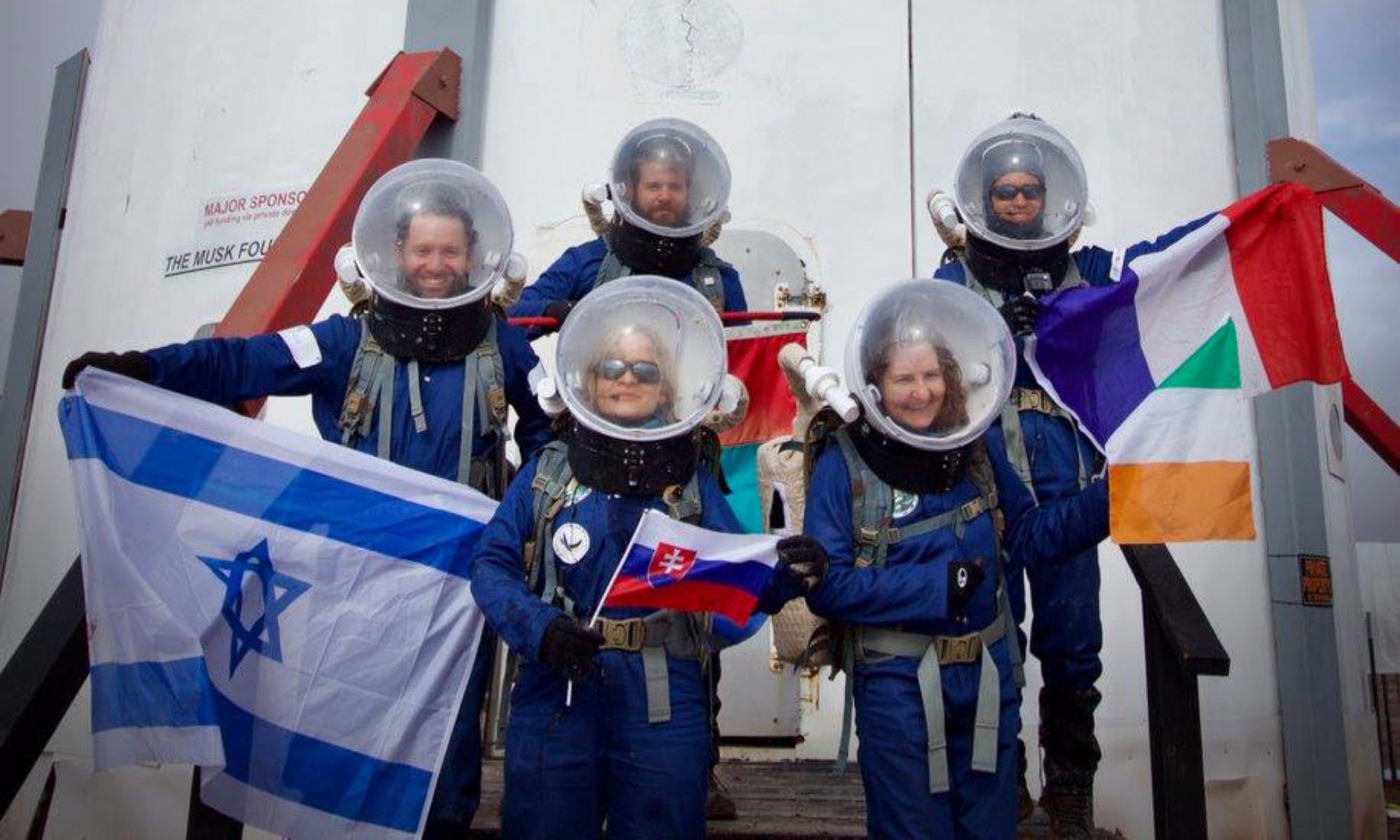
EVA #2

Author: Nathan Hadland

Purpose of EVA: Terrain familiarization and sample collection

Start time: 1500 hrs

End time: 1545 hrs

Narrative: EVA #2 initiated a 5-minute decompression at 1500 hours, and moved out to Curiosity and Spirit. After reporting SOC and hours, we progressed north along Cow Dung Road. We dismounted the rovers and moved east on foot to the VS-17 signal panel placed by EVA #1. We then moved slightly farther eastward to the ridge with minimal snow cover for sample collection. We collected 3 samples at different stratifications on the ridge and recorded GPS locations. After sample collection, we returned to the rovers and proceeded back to the Hab and successfully pressurized in the air lock.

Destination: Marble Ritual

Coordinates: 0518700/4250700

Participants: Nathan Hadland (XO), Hannah Blackburn (LSO), Cynthia Montanez (GHO), Abdul Elnajdi (GEO)

Roads and routes per MDRS Map: North on Cow Dung Road via rovers until adjacent to Marble Ritual, east on foot to Marble Ritual

Mode of travel: Rovers (Spirit and Curiosity) and foot travel


EVA Report – January 03rd


EVA #: 12

Autor: Luz Maria Agudelo Urrego

Purpose of EVA: weather observation; Radio measurements; EVA and EMU evaluation project; Reliability and maintenance

Start time: 10:18

End time: 12:25

Narrative: Shefali, Ben and Luz Ma, drove Curiosity and Spirit along Cow Dung Rd, and stop before the original destination, Brahe, to assure the charge of the rovers Curiosity and Spirit was enough for the way back to the Habitat. They took weather observation, radio measurements, performed a reliability scenario, and explored the canyon. An engineering EVA was performed at the end of the excursion.

Destination: Along Cow Dung Rd

Coordinates (use UTM NAD27 CONUS): 12S 517950, 4253860

Luz Ma
ENG
Crew 218

EVA Report – January 02nd


 EVA #: 10

Author: Pat Pesa

Purpose of EVA: Seismometric measurements; EVA and EMU evaluation project; Filming crew

Start time: 11:17

End time: 12:35

Narrative: Jonathon, Pat, and Shefali took the short Rover trip to the Marble Ritual. They were met there by a guest filming crew to observe research activity. Seismic measurements were taken at the site at several distance intervals.

Destination: Marble Ritual

Coordinates (use UTM NAD27 CONUS): 12S 518800, 4250700

EVA Participants: Pat Pesa, GEO; Jonathan Buzan, SCI; Shefali Rana, HSO

Road(s) and routes per MDRS Map: Cow Dung Road

Mode of travel: Driving and walking

Vehicles you will be using (If applicable): Curiosity and Spirit

EVA #: 11

Author: Cesare Guariniello

Purpose of EVA: weather observation; Geology samples collection; Radio measurements; Filming crew

Start time: 13:39

End time: 15:28

Narrative: Cesare, Luz Ma and Ben, together with a guest from the filming crew, drove the rover along Cow Dung Rd and Galileo Rd. They took weather observation, radio measurements, and collected rock samples before going to the lower lands along Cactus Rd. Here, they took more measurements before heading back to the hab. An engineering EVA was performed at the end of the excursion

Destination: Galileo / Cactus Rd

Coordinates (use UTM NAD27 CONUS): 12S 520200, 4251500

EVA Report – January 1st

Crew 218 EVA Report 01-01-2020

EVA #: 8

Author: Cesare Guariniello

Purpose of EVA: Seismometric measurements; EVA and EMU evaluation project; reliability project

Start time: 10:57

End time: 12:59

Narrative: Pat and Cesare drove East on Galileo / Cactus road on a cold, battery-draining day. Once they found a suitable spot in the lowlands they set up the seismometric experiment. Then, they performed a reliability and repair study, evaluating the execution of operations via radio communication. Pat served as the expert, guiding Cesare via radio. The experiment simulated a rover battery failure to be repaired in 10 steps, which included cleaning the area around the seats from ice, putting the map in the glovebox, and reciting poetry. After this, Pat and Cesare performed seismometric readings before heading back to the hab

Destination: Galileo / Cactus Rd

Coordinates (use UTM NAD27 CONUS): 12S 519850, 4252000

EVA Participants: Cesare Guariniello, CMD; Pat Pesa, GEO

Road(s) and routes per MDRS Map: Cow Dung Road and Galileo / Cactus Rd

Mode of travel: Driving, then work in the field and walking

Vehicles you will be using (If applicable): Curiosity and Spirit

EVA #: 9

Author: Cesare Guariniello

Purpose of EVA: Weather observation; EVA and EMU evaluation project; reliability project

Start time: 14:18

End time: 14:54

Narrative: After heading out, the crew found out that the rovers were not fully charged. The commander called for cancellation of the driving, and allowed the crewmembers to perform weather observation and reliability project in the vicinity of the habitat. The crew reached the MDRS sign and simulated a situation of radio failure, with consequent EVA abortion and implementation of protocols for
communication and safety, which included having the crewmember experiencing a radio failure to walk between the two crewmembers with working apparatus.

Destination: Brahe Hwy (intended), vicinity of the hab (actual)

Coordinates (use UTM NAD27 CONUS): 12S 519850, 4252000

EVA Participants: Ben Durkee, JOU; Luz Ma Agudelo, ENG; Shefali Rana, HSO

Road(s) and routes per MDRS Map: vicinity of the habitat

Mode of travel: Walking

Vehicles you will be using (If applicable): None

Cesare Guariniello, Commander

EVA Report – December 31st

EVA #: 6

Author: Cesare Guariniello

Purpose of EVA: weather observation project; EVA and EMU evaluation project

Start time: 9:57
End time: 12:01

Narrative: Cesare, Ben, and Shefali drove to the north side of Kissing Camel range, where Ben took radio measurements and Cesare proposed potential scenarios for crew decision-making.

After collecting a few rock samples, the crew drove the rovers to the south of the range, which is exposed and clear of snow.

More radio measurements were taken, and the crew could climb the south side of the West Kissing Camel range. On the way back, Ben took more radio measurements along the first ridge south of the habitat.

Destination: Kissing Camel

Coordinates (use UTM NAD27 CONUS): 12S 518300, 4249000

EVA Participants: Cesare Guariniello, CMD; Ben Durkee, JOU Shefali Rana, HSO

Road(s) and routes per MDRS Map: Cow Dung Road to the south of Kissing Camel Range

Mode of travel: Driving, then work in the field and walking

Vehicles Used: Curiosity and Spirit

EVA #: 7

Author: Pat Pesa

Purpose of EVA: crew decision-making evaluation and radio measurements (during transfers); seismic measurements to evaluate subsurface layers (once at destination); EVA and EMU evaluation (once back in habitat)

Start time: 12:49

End time: 14:57

Narrative: Luz Ma and Pat took the Curiosity and Spirit rovers to just south of Kissing Camel range to the Hippo formation. Pat set up his Seismic equipment with the help of Luz Ma (lots of untangling wires) and started recording data.
It is a quite fun experiment because, after the tedious setup, you get to "smack" the ground with a sledgehammer to generate waves for the geophones to pick up! After these tests, Luz Ma continued her Climate and Weather readings, and we embarked on a short journey near the area.

Besides the overabundance of slushy snow and mud, the EVA was greatly successful and led to some great science and exploration.

Destination: South of Kissing Camel along Cow Dung Rd

Coordinates (use UTM NAD27 CONUS): 12S 51900, 4248600

EVA Participants: Pat Pesa, GEO; Luz Ma Agudelo, ENG

Road(s) and routes per MDRS Map: Cow Dung Road to the northwest of Zubrin’s head

Mode of travel: Driving and walking

Vehicles Used: Curiosity and Spirit

Crew 218 EVA Report 30Dec2019

EVA #: 4

Author: Shefali Rana

Purpose of EVA: weather observation project; EVA and EMU evaluation project

Start time: 10:10

End time: 11:22

Narrative: Luz Ma and Shefali took Curiosity and Spirit up to the Galileo Rd intersection and took observation readings for weather project. The EVA duration was about one hour. After being back in the habitat, Luz Ma and Shefali filled questionnaires for the EVA and EMU evaluation projects.

Destination: Galileo Rd

Coordinates (use UTM NAD27 CONUS): 12S 519050, 4252000

EVA Participants: LuzMa Agudelo, ENG; Shefali Rana, HSO

Road(s) and routes per MDRS Map: Cow Dung Road

Mode of travel: Driving, then work in the field and walking

EVA #: 5

Author: Cesare Guariniello

Purpose of EVA: crew decision-making evaluation and radio measurements (during transfers); seismometric measurements to evaluate subsurface layers (once at destination); EVA and EMU evaluation (once back in habitat)

Start time: 13:15

End time: 15:59

Narrative: After loading on the rovers the necessary equipment for the research projects, we began driving along Cow Dung Road. The road is well marked, with streams of icy water melting down. Snow is completely melted in certain point and about one inch deep on others. The ride had been very smooth and safe, and the rovers made it to the intended destinations with good residual charge. Ben took radio measurement along the road, as a passenger on Curiosity rover. Once at destination, we began to slowly prepare Pat’s experiment. This required us to extend a measuring tape for about 30 meters and, after having removed some snow, place 24 sensors one meter apart from each other. The seismometric sensors, connected to a laptop, record the propagation of seismic waves generated by a hammer hitting a metal plate that we laid on the ground at various locations along the sensor network. The preparation took about 25 minutes and gave us a good idea of the challenges faced by astronauts working in EVA. After the experiment, we walked the first few feet of Brahe Hwy before heading back. On our way back, Ben took more radio measurements south of the intersection with Galileo Rd and close to the habitat.

Destination: Brahe Hwy at Glistening Sea

Coordinates (use UTM NAD27 CONUS): 12S 517750, 4254700

EVA Participants: Cesare Guariniello, CMD; Pat Pesa, GEO; Ben Durkee, JOU

Road(s) and routes per MDRS Map: Cow Dung Road to Brahe Hwy intersection (Glistening Sea and White Moon area)

Mode of travel: Driving and walking

EVA Report 29Dec2019

EVA #: 3

Author: Cesare Guariniello

Purpose of EVA: weather observation project; radio mapping project; collection of geological samples

Start time: 12:00

End time: 13:18 (including engineering EVA)

Narrative: one walking EVA has been approved for today. Due to the presence of snow, the commander joined the EVA for better knowledge of the terrain. Working on snow was easy and safe, and a couple of narrow streams formed by the melted water were less than one step across. At the end of the simulated depressurization cycle, the crew noticed that the front door was still blocked by some snow and Pat completed the shoveling process. At the same time, both Ben and Luz Ma experienced problems with their equipment, therefore a cycle of re-pressurization was initiated and the crew re-entered the habitat to fix a hat and a pair of shoes. After the second depressurization, Cesare, Luz Ma and Ben egressed and Luz Ma and Ben became their measurements with the help of Cesare. Then, the crew grabbed their bag with tools, EVA first aid kit, map, and rock hammer and walked towards the MDRS sign and out along Cow Dung Road to Marble Ritual. Radio measurements were collected along the way. Once at destination, both weather data and radio measurements were collected before the crew headed back to the habitat. An engineering EVA was performed before ingress.

Destination: Marble Ritual

Coordinates (use UTM NAD27 CONUS): E518700, N4250800

EVA Participants: LuzMa Agudelo, ENG; Ben Durkee, JOU; Cesare Guariniello, CMD.

Road(s) and routes per MDRS Map: Cow Dung Road

Mode of travel: Walking

EVA Report – December 23rd


EVA #1

Author: Shefali Rana

Start time: 11.20 AM

End time: 12.16 AM

Narrative: Team conducted a training EVA for Marble Ritual. Crew members collected and loaded rock samples at the collection baskets on Cow Dung Road. CMD and JOU went up the ridge and explored the vantage point. Post survey, CMD, HSO, and JOU came down the trail and dislodged some rocks for analysis. The trip back was led by Spirit followed by Curiosity.

Destination: Marble Ritual

Coordinates (use UTM NAD27 CONUS): 12S 518700 4250800

Participants: Cesare (CMD), Shefali (HSO), Ben (JOU)

Road(s) and routes as per MDRS Map: Cow Dung Road

Mode of travel: Spirit and Curiosity

EVA #2

Author: Shefali Rana

Start time: 12.36 PM

End time: 1.20 PM

Narrative: Team conducted an egress/ ingress training EVA for Marble Ritual. Crew members collected and loaded rock samples at the collection baskets on Cow Dung Road. ENG and GEO went on the trail by the ridge and led the way back to Hab with Spirit leading the way.

Destination: Marble Ritual

Coordinates (use UTM NAD27 CONUS): 12S 518700 4250800

Participants: LuzMa (ENG), Pat (GEO)

Road(s) and routes as per MDRS Map: Cow Dung Road

Mode of travel: Spirit and Curiosity


Shefali Rana

HSO

Crew 218

EVA Report – December 23rd


EVA #1

Author: Shefali Rana

Start time: 11.20 AM

End time: 12.16 AM

Narrative: Team conducted a training EVA for Marble Ritual. Crew members collected and loaded rock samples at the collection baskets on Cow Dung Road. CMD and JOU went up the ridge and explored the vantage point. Post survey, CMD, HSO, and JOU came down the trail and dislodged some rocks for analysis. The trip back was led by Spirit followed by Curiosity.

Destination: Marble Ritual

Coordinates (use UTM NAD27 CONUS): 12S 518700 4250800

Participants: Crew CMD, HSO, JOU

Road(s) and routes as per MDRS Map: Cow Dung Road

Mode of travel: Spirit and Curiosity

EVA #2

Author: Shefali Rana

Start time: 12.36 PM

End time: 1.20 PM

Narrative: Team conducted an egress/ ingress training EVA for Marble Ritual. Crew members collected and loaded rock samples at the collection baskets on Cow Dung Road. ENG and GEO went on the trail by the ridge and led the way back to Hab with Spirit leading the way.

Destination: Marble Ritual

Coordinates (use UTM NAD27 CONUS): 12S 518700 4250800

Participants: Crew ENG, GEO

Road(s) and routes as per MDRS Map: Cow Dung Road

Mode of travel: Spirit and Curiosity

Shefali Rana

HSO

Crew 218

EVA Report – December 22nd


Crew 218 EVA Request 22-DEC-2019

EVA #: 1

Today’s Date: 22 Dec 2019

Requested EVA Date: 23 Dec 2019

Requested start time for EVA: 11:00

Requested end time for EVA: 12:15

Does weather report support EVA at this time? Yes

Purpose of EVA: Exploratory EVA to familiarize with use of space suits, use of rovers with gear, and communication procedures

Destination: Marble Ritual

Coordinates (use UTM NAD27 CONUS): E518700, N4250800 EVA Participants: Cesare Guariniello, CMD; Ben Durkee, JOU; Shefali Rana, HSO

Road(s) and routes per MDRS Map: Cow Dung Road, then walk East towards Marble Ritual

Mode of travel: Driving and walking

Vehicles you will be using (If applicable): Spirit and Curiosity

EVA #: 2

Today’s Date: 22 Dec 2019

Requested EVA Date: 23 Dec 2019

Requested start time for EVA: 12:45

Requested end time for EVA: 14:00

Does weather report support EVA at this time? Yes

Purpose of EVA: Exploratory EVA to familiarize with use of space suits, use of rovers with gear, and communication procedures

Destination: Marble Ritual

Coordinates (use UTM NAD27 CONUS): E518700, N4250800 EVA Participants: Pat Pesa, GEO; LuzMa Agudelo, ENG

Road(s) and routes per MDRS Map: Cow Dung Road, then walk East towards Marble Ritual

Mode of travel: Driving and walking

Vehicles you will be using (If applicable): Spirit and Curiosity

EVA #: 3

Today’s Date: 22 Dec 2019

Requested EVA Date: 23 Dec 2019

Requested start time for EVA: 14:30

Requested end time for EVA: 15:45

Does weather report support EVA at this time? Yes

Purpose of EVA: Exploratory EVA to familiarize with use of space suits and communication procedures. One crew member cannot perform EVA on rovers, therefore this EVA is to let him familiarize with EVAs with the traditional expedition to Marble Ritual, but on foot

Destination: Marble Ritual

Coordinates (use UTM NAD27 CONUS): E518700, N4250800 EVA Participants: Cesare Guariniello, CMD; Jonathan Buzan, SCI

Road(s) and routes per MDRS Map: Cow Dung Road, then walk East towards Marble Ritual

Mode of travel: Walking

Vehicles you will be using (If applicable): None

Please note the reason for request of third EVA.

Cesare

Commander, MDRS 218

Copyright © The Mars Society. All rights reserved. | Main Site